Archive number No. 14 (1016) dated April 1, 2014 — News
NATIVE EDGE
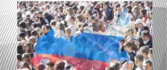
This year our region will celebrate its 80th anniversary. On the eve of the anniversary, we decided to remember how the Kursk borders changed at different times.
Outpost on the border of Kievan Rus
Kursk was first mentioned in the Life of Theodosius of Pechersk around 1032. This year is officially considered the founding date of the city, although it is obvious that it existed before. Since the end of the 11th century, Kursk became one of the most powerful outposts on the border of Kievan Rus. In 1185, Prince Vsevolod of Kursk sent a squad against the Polovtsians. The high combat training and courage of our ancestors is narrated in the famous “Tale of Igor’s Campaign”: “And my Kuryans are experienced warriors, trained under pipes, groomed under helmets, fed from the end of a spear, their paths are known, their ravines are known to them, their bows are stretched, quivers open, sabers sharpened, they themselves gallop like gray wolves across the field, seeking glory for the prince and honor for themselves.”
The city was part of either Chernigov or Smolensk, Pereyaslavl and Suzdal principalities. Having become the center of an appanage principality, Kursk steadfastly endured both the internecine clashes of the Russian princes and the Mongol invasion of Batu Khan. From 1360 until the end of the 15th century, Kursk was part of the Grand Duchy of Lithuania, and in the 16th–17th centuries it was considered an important defensive point of the Moscow State, which it became part of in 1508. As part of the centralized Russian state, the Principality of Kursk still remained the southern border region of Rus'.
There are known mentions of Kursk in the “Book of the Big Drawing” (1517), in the decree of Ivan IV the Terrible of 1582, when the sovereign ordered the exile of “kromeshniks, rebels, rebels” “to the outlying cities of Sevsk and Kursk.”
The 16th century was a turning point in the history of Kursk. In 1597, a new fortress was erected in the city. Here, by order of the tsar, a mass of so-called “transfers” arrived - people forcibly transferred for military service and other matters of national importance. Kursk gave shelter to peasants and artisans, the homeless and serfs who flocked to the south, fleeing the tyranny of officials. Many were driven by the famine that gripped Central Rus' in 1601 and 1603. After the construction of a fortress on a river cliff above the Kur and Tuskary, the city became the military-administrative and economic center of a vast territory in the south of the Russian state that was gaining strength.
Between whom was the Kursk province divided?
In 1708, Kursk was assigned to the Kyiv province. In 1719, it was divided into four provinces, the territory of the current Kursk region was divided between two - Belgorod and Sevsk. In 1727, the Belgorod governorate was created, which included the Belgorod, Sevsk and Oryol provinces. In 1749 it was transformed into the Belgorod province.
In 1779, the Kursk governorate appeared, consisting of 15 counties (Belgorod, Bogatensky, Dmitrievsky, Korochansky, Kursk, Lgovsky, Novooskolsky, Oboyansky, Putivlsky, Rylsky, Stary Oskolsky, Sudzhansky, Timsky, Fatezhsky and Shchigrovsky). In 1797 it was transformed into the Kursk province, which existed until 1928.
In 1928, the Central Black Earth Region was created on the territory of the Voronezh, Kursk, Oryol and Tambov provinces. Most of the Kursk province was included in the Kursk, Belgorod and Lgov districts, and its east - in the Voronezh and Ostrogozh districts. In 1929, the Starooskolsky district was formed from 13 districts, separated from the Voronezh (8 districts), Ostrogozhsky (three districts), Kursk and Belgorod (one district each) districts. In 1930, the districts were liquidated, and the districts began to report directly to the regional center.
Part of the land went to neighbors
The Kursk region was created by a resolution of the Presidium of the All-Russian Central Executive Committee of June 13, 1934. It included 60 districts, including 21 from the former Oryol and Voronezh provinces. At the time of its formation, about 5 million people lived in the region, of which more than 4 million lived in rural areas.
In 1935, as a result of a revision of the intraregional administrative-territorial division, 93 districts were formed. Subsequently, the territory of the region decreased: according to the resolution of the Central Executive Committee of the USSR dated September 27, 1937, 25 districts were transferred to the formed Oryol region. In July 1944, four more districts joined it. In January 1954, in connection with the formation of the Belgorod and Lipetsk regions, the following were transferred from the Kursk region: to the first - 23 districts, to the second - three districts. Since 1954, the boundaries of the region have not changed.
* * *
Help "DDD"
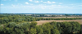
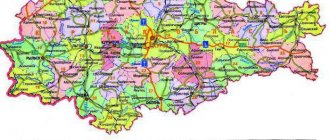
Now the Kursk region is part of the Central Federal District of the Russian Federation. Its area is about 30 thousand square kilometers. The population today is more than 1 million 119 thousand people. The northernmost point of the region is located in the Zheleznogorsk district, the southern - in Belovsky, the western - in Rylsky, and the eastern - in Kastorensky district.
The length of the region’s territory from north to south is 171 kilometers, from east to west – 305 kilometers. The Kursk region borders in the northwest with Bryansk, in the north with Oryol, in the northeast with Lipetsk, in the east with Voronezh, and in the south with Belgorod regions. The length of the borders is 1250 km.
The Kursk region is again a border region. The external borders with the Sumy region of Ukraine in the southwest and west are 296 kilometers and have the status of the state border of Russia.
Established symbols of the Kursk region
Root hermitage, Battle of Kursk (Kursk Bulge), Kursk nightingale, Maryino - the estate of the Baryatinsky princes in the Rylsky region, nightingale region, Streletskaya steppe, black soil, Kursk magnetic anomaly (KMA), Kursk Antonovka, Kursk Root Icon of the Mother of God “The Sign”, godmother move (in Kursk province).
More than 96% of Kursk residents are Russians
There is no “nationality” column in Russian passports today. Therefore, it is possible to obtain information about the ethnic composition of the population only during the All-Russian Census. Moreover, in accordance with the Constitution of the Russian Federation, everyone has the right to determine and indicate their nationality. A person may not answer this question at all.
During the last census, in 2010, only less than 5% of the region's residents did not indicate their nationality. Almost 96.5% of respondents, or 1 million 37 thousand Kursk residents, identified themselves as Russians. By the way, in the Russian Federation as a whole, 80% were Russian.
Ukrainians are in second place in the Kursk region. True, their number since the 2002 census has decreased from 1.7% to 1.27%. In 2010, there were 13.5 thousand of them. But the share of Armenians has increased slightly, there are 6 thousand of them in the region.
In total, according to Kurskstat, more than 130 nationalities live in our region.
Ivan PROKHOROV
Share link:
Subscribe to “For Each Other”:
Yandex News Yandex Zen Google News YouTube Video
Attractions
- The Kornaya Pustyn Monastery is an ancient Russian architectural monument located in the village of Sloboda. The monastery was founded by Tsar Fyodor Ioannovich on the site where the image of the Blessed Virgin Mary was found. The icon was in the roots of the tree. For this she was called “The Sign” Kursk Root. Since then, the monastery has become a popular place to visit for pilgrims and tourists.
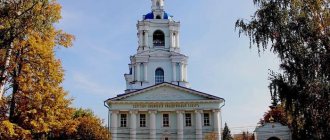
- Kursk Regional Museum of Local Lore, located on the territory of the Znamensky Cathedral. The museum has more than 180 thousand antiques in its collection.
- Water mill in the village of Krasnikovo. A monument of wooden architecture built at the end of the nineteenth century. The mill was built from wood without the use of nails.
- Shamil Tower is the main attraction of the city of Lgov, Kursk region. A three-tiered decorative structure in the form of a watchtower was built in 1870 by Prince Baryatinsky.
- The Kursk magnetic anomaly is the hallmark of the Kursk region - the largest iron ore deposit in the world. Mineral reserves amount to billions of tons. The compass does not work in this place.
Up ▲ — Reader reviews (3) — Write a review ▼ — Print version
| e-mail, city: St. Petersburg | |
The article contains a number of inaccuracies. Kursk was never part of the Smolensk and Suzdal principalities. In the XIV-XVI centuries. Kursk did not exist, so it could not be considered any “important defensive point of the Moscow state” at that time. The construction of the Kursk fortress dates back to 1596, and not to 1597. In 1727, the Belgorod province was formed, not the governorship; there was no “transformation” of the Belgorod province in 1749. Governorship and province are synonymous; there was no “transformation” of the Kursk “government” into a “province” in 1797 (this is a common misconception, widely represented in reference literature). As an important addition, we should point out the fact of the transfer from the Kursk province in 1925 of the city of Putivl with the adjacent district to the Ukrainian SSR.
| Andrey | 5 April 2014, 13:59:47 |
An excellent article, but I wanted to add a little)) Among the “migrants” in the period of the late 16th and early 17th centuries, there were a large number of so-called “Byar children”, this is a military class class, later they began to be called odnodvortsy. They were allocated land on which they farmed, and the head of the family was in the military service of the state. Representatives of the same palace occupied officer positions. The settlements they founded often bore the surnames of the founders in their names. This was the case with my ancestors, who founded the settlement, which is now called Apalkovo, and in the 1645 census books it was written as Opalkova. Later, other members of the same palace, for example the Lobyntsevs, began to gain strength in this village. These same-palaces became the founders of many families that are considered Kursk. As for the national composition, in the Kursk province of 18-19 many called themselves Sevryuks (most likely these are descendants of northerners, Severians). There were also nationalities who called themselves Sayans, Goryuns, after 1917 they became Russians. And also in the Kursk region there is a huge number of Ukrainians who have forgotten their roots.
| passer-by | 9 April 2014, 09:52:05 |
| city: Kursk | |
To the established symbols of the Kursk region we must add the Kursk tram - the 2nd in Tsarist Russia, opened in 1898 (1st - in Nizhny Novgorod).
Questions and answers
What is the vehicle code in the region?
Region code - 46
What time zone is it in?
The Kursk region lives according to Moscow time. Time zone UTC +3
How many settlements are there in the Kursk region?
There are 2,807 settlements in the Kursk region: 5 cities of regional significance, 5 cities of regional significance, 22 urban-type settlements and 2,775 rural settlements.
What is the total area of the subject?
The area of the region is 29.8 thousand km²
Economy and industry of the Kursk region
The economic component of the Kursk region is represented by agriculture and iron ore mining. Grain and fodder crops are grown on agricultural lands, and animals are raised. Huge areas of land are given over to pastures for meat and dairy cattle.
Industrial enterprises, which can be viewed using Yandex maps of the Kursk region, produce:
- electrical products;
- elevator equipment;
- bearings;
- drilling rigs;
- Rubber products.
The region also has several light industry enterprises that produce linen fabrics and knitwear, but the share of their products in the overall economy of the region is not large.
The construction industry is represented by several trusts that are engaged in the construction of residential buildings and roads in the region, and produce building materials and structures.
Industry approach
Plant growing has a wide profile. All in. In parts of the region, the grain-potato direction with crops of industrial crops (sugar beets, hemp, sunflower) predominates; in the southern parts, the beet direction with crops of sunflower and grain crops predominates. Grain crops occupy 58.5% of the sown area, fodder crops – 24.3%, potatoes and melons and vegetables – 8.6%, industrial crops – 8.6%. In 2004, the gross grain harvest amounted to 1599 thousand tons (15th place in the Russian Federation), sugar beets - 1177 thousand tons (7th place), sunflower seeds - 10.9 thousand tons (20th place), potatoes - 1159.4 thousand tons (5th place), vegetables - 170.4 thousand tons (38th place). Gardening has received great development.