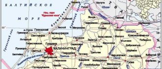
City in Pskov region, Russia
| Sebezh Sebezh | |
| City [1] | |
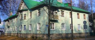
| Panorama of Sebezh | |
| Coat of arms | |
| Location of Sebezh | |
| Sebezh Location of Sebezh Show map of Russia Sebezh Sebezh (Pskov region) Show map of Pskov region | |
| Coordinates: 56°16'N 28°29'E / 56.267°N Latitude 28.483°E / 56.267; 28483 Coordinates: 56°16'N 28°29'E. / 56.267°N Latitude 28.483°E / 56.267; 28 483 | |
| A country | Russia |
| Federal subject | Pskov region [1] |
| Administrative region | Sebezhsky district [1] |
| First mention | 1414 [2] |
| City status from | 1772 [2] |
| Height | 130 m (430 ft) |
| population size (2010 Census) [3] | |
| • General | 6 375 |
| • Evaluate (2018) [4] | 5 401 (-15,3 % ) |
| Administrative status | |
| • Capital from | Sebezhsky district [5] |
| Municipal status | |
| • Municipal district | Sebezh municipal district [6] |
| • Urban village | Urban settlement Sebezh [6] |
| • Capital from | Sebezh municipal district [7], urban settlement Sebezh [6] |
| Timezone | UTC+3 (MSK[8]) |
| Postal code [9] | 182250, 182251, 182299 |
| Dialing code(s) | +7 81140 |
| OKTMO ID | 58654101001 |
Sebezh
(Russian: Sebezh, Polish: Siebież) is a city and administrative center in Sebezhsky District in Pskov Oblast, Russia, located in a picturesque setting between lakes Sebezhskoye and Brewer 189 kilometers (117 mi) south of Pskov, the administrative center of the region. Population: 6,375 (2010 census); [3] 7,138 (2002 census); [10] 9,497 (1989 Census). [eleven]
History[edit]
Historical affiliation
Grand Duchy of Lithuania 1414-1535 Grand Duchy of Moscow 1535-1547 Tsarism of Russia 1547-1618 Commonwealth 1618-1772 Russia Empire 1772-1917 Russia Republic 1917 Soviet Russia 1917-1922 Soviet Union 1922-1991 Russia Federation 1991-present more
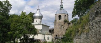
It was first mentioned in 1414 as a fortress defending Pskov from the south, when it was sacked by Vytautas of Lithuania. [2] Prince Ivan Shuisky built a wooden fortress here in 1535. In the 16th century, the fortress defended the western approaches to the Grand Duchy of Moscow. The Poles captured it during the Livonian War and held it until the First Partition of Poland. The dismantled fortifications of Sebezh were strengthened on the orders of Peter the Great during the Northern War. The castle hill is still dominated by the Roman Catholic Church, built in 1625-1648 and re-consecrated as a Russian Orthodox Church in 1989.
Sebezh until 1918
Until 1927, Sebezh was the seat of Sebezhskly Uyezd of Pskov Governorate (in Vitebsk Governorate before 1924). [ citation needed
]
On August 1, 1927, counties and akimats were abolished and Sebezhsky District, with its administrative center in Sebezh, was created as part of the Velikiye Luki Okrug in the Leningrad Region. [12] It included parts of the former Sebezh district. [13] On June 3, 1929, Sebezhsky District was transferred to the Western Region. [13] On July 23, 1930, the districts were also abolished, and the districts were directly subordinated to the region. [12] On January 29, 1935, the Western Region was abolished, and the district was transferred to the Kalinin Region, and on February 5 of the same year, the Sebezhsky District became part of the Velikoluksky Okrug of the Kalinin Region [12], one of the districts adjacent to the state border of the Soviet Union. On May 4, 1938, the area was transferred to the Opochinsky Okrug. [12] On February 5, 1941, the district was abolished. [12] From July 9, 1941 to July 17, 1944, Sebezh was occupied by German troops. [2] On August 22, 1944, the area was transferred to the newly formed Velikolukskaya Oblast. [12] On October 2, 1957, the Velikolukskaya region was abolished, and the Sebezhsky district was transferred to the Pskov region. [12]
According to the 1939 census, 845 Jews lived in Sebezh. The SS Division "Totenkopf" arrived in the city on July 7, 1941. Many Jews managed to escape during this time. Throughout the occupation, which lasted from July 1941 to July 1944, the Ortskomandantur operated in the city. There was also Ordnungsdienst. The ghetto was created in September 1941 and existed until March 1942. After that it was liquidated. During the liquidation, more than 100 Jews were shot in pits. Local Russian police officers were responsible for the shooting. [14]
Natural attractions of Sebezh and surrounding areas
The surroundings of Sebezh are truly a lake region: in a small area there are about 200 reservoirs. Tourists should first of all admire the largest lakes – Sebezhskoe and Orono, which wash the outskirts of the city. In addition to reservoirs, guests of Sebezh are recommended to visit the Kazan Holy Spring and Petrovskaya Mountain.
Sebezhskoye Lake
- Coordinates: 56.264262, 28.498819.
Ancient Sebezh was built on the shore of the vast Sebezh Lake. It is believed that it was the reservoir that gave the name to the settlement. The lake has an elongated shape, its length is 7 kilometers, width – 3 kilometers.
The average depth is 5 meters, although there are dips up to 18 meters deep. At one time, passenger ships sailed on the reservoir. There is a lot of fish in Sebezhskoye; among dozens of species, the most numerous are bream and pike perch.
Lake Orono
- Coordinates: 56.266832, 28.459158.
On the opposite outskirts of the city lies Lake Orono, otherwise called Raven. Orono is almost three times smaller in size than Sebezhsky. In addition to Sebezh, there are three more settlements on the banks of the reservoir: Ugarinka, Ilovo and Mironovo.
The lake is rich in fish; it is home to perch, pike perch, pike, ide, crucian carp, bream and many other species. If you're lucky, you can catch crayfish.
Petrovskaya mountain
- Coordinates: 56.283285, 28.483943.
The high hill opposite the central market has several names: Petrov Val, Petrovskaya Gora, Petrov Gora, Petrovsky fortifications. According to legend, in 1705 Peter I ordered the construction of a defensive fortress on the Sebezh hill. This story is partly confirmed by archaeological finds in the hill area.
The mountain received the name of the first Russian emperor, and in 1972 a memorial plaque was installed on its upper platform. According to the inscription on the monument, the peak was the site of fortifications during the Northern War. Today the hill is used as an observation deck, from which you can clearly see Castle Hill.
Embankment
- Address: Naberezhnaya street.
Sebezhskaya embankment is one of the most picturesque places in the city. The promenade stretches along the edge of the cape, the asphalt road is almost at the same level with the water. Benches and tall street lamps are installed along the embankment.
On a small pier there is an original wooden gazebo, made in the shape of a ship. Local residents love to walk next to the lake and feed seagulls and swans from the shore.
Square "Lebyazhy"
- Address: Naberezhnaya street.
Relatively recently, a small but very beautiful and landscaped park was laid out near the embankment. The new place for leisure for the townspeople was called “Swan Square”, as beautiful white swans can often be seen here.
According to local residents, black swans used to fly to the lake, but recently the rare birds have not appeared on Sebezh land.
There are several interesting objects in the park: figures of swans, reed-shaped lanterns, benches with swan wings. In October 2020, a cozy corner was decorated with a sculpture of Pike from the fairy tale “At the Pike’s Command.”
Kazan Holy Spring
- Coordinates: 56.262611, 28.470532.
On the territory of the National Park, in the middle of a pine forest, a revered holy spring gushes out of the ground. Even before the Revolution, a small wooden chapel was built above the spring in honor of the Kazan Icon of the Mother of God. During Soviet times, the building was completely destroyed in order to stop pilgrimages to the shrine.
In 1998, a new chapel was erected over the spring. There are steps leading up to the church, and information stands are installed on both sides of the stairs. The water of the holy spring is healing even from the point of view of science, because it contains silver ions.
Lake Sentsy
- Coordinates: 56.291823, 28.473172.
Another beautiful lake is located within Sebezh. It is located almost in the central part of the city. Street 7 November approaches almost right next to it.
Latric Island
- Coordinates: 56.279201, 28.506657.
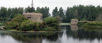
The island of Latrik, known primarily from an archaeological point of view, is located in Lake Sebezhskoye and is clearly visible from Castle Hill. As archaeologists say, sites of ancient man were discovered here. Also, since the island is not currently in use, it is quite possible to find military supplies from the war on it.
Culture and recreation[edit]
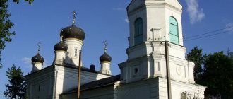
Holy Trinity Church
Sebezh contains one cultural heritage monument of federal significance and an additional fifteen objects classified as cultural and historical heritage of local significance. [15] A state-protected monument is the Trinity Church, formerly a Catholic church, consecrated in 1648, when Sebezh was still part of the Polish-Lithuanian Commonwealth. This is probably the oldest Baroque building in Russia. [ citation needed
] Since 2013, the church has been closed to the public due to reconstruction.
In Sebezh there is the Sebezh Regional Museum, founded in 1927 and representing local collections. [16]
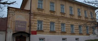
Sebezh architectural monuments
More than 20 Sebezh buildings have been recognized as architectural monuments of regional significance. Most of the century-old houses are located in the historical center of the city - on Proletarskaya Street.
House of the merchant Bruskin
- Address: Proletarskaya, 31.
The two-story stone mansion on Proletarskaya Street is one of the most famous buildings in the city. An unremarkable house in the neoclassical style in the 19th century belonged to the merchant of the 2nd guild Moses Bruskin.
Moisei Izrailevich traded timber, and his wife took care of a large family. During Soviet times, the city council was located in the mansion. The architectural monument has been preserved in good condition; today the premises are occupied by a notary's office and other organizations.
House of merchant Selyugin
- Address: Sovetskaya street, 13.
The brick mansion of the Sebezh merchant Selyugin was built in 1890, as evidenced by the mortgage board on the facade of the building. Above the name of the owner and the date of construction, a short prayer is inscribed in capital letters: “Lord, protect this house from all evils and do not forsake those who trust in Thee.”
The businessman's former possessions are one of the richest in the city: in addition to a two-story house, they include a warehouse, a trading store and a number of outbuildings.
Today, several families live in the renovated merchant house; modern plastic windows adorn the window openings of the architectural monument. One of the warehouses of the architectural complex is used as a store.
House of the priest
- Address: Zamkovaya, 12.
Not far from the former Church of the Holy Trinity there is a house in which Catholic clergy once lived. According to local historians, the construction of a small one-story building was completed in 1890. After the church was closed, the priest's house was nationalized.
Since 1948, it housed the district military registration and enlistment office. Nowadays, the department of the Federal Tax Service of the Russian Federation for drug control operates in the building, but the authorities plan to transfer the architectural monument to the Trinity Church as a clergy house.
Medunetsky's House
- Address: Zamkovaya, 6.
The rich and prolific Medunetsky family owned several buildings on Proletarskaya and neighboring streets. One of the largest mansions of the landowner (Proletarskaya, no. 18) was erected in the first half of the 19th century.
In the first years of Soviet power, the house became the property of the working people, after the war it was adapted into a House of Culture. The second floor of the building was occupied by the library and the National Park office. Then the old house was transferred into private hands. When the mansion fell into disrepair, it was simply abandoned.
Over the past years, the architectural monument has not been restored. The dilapidated building makes a depressing impression; it is better to observe it from a distance, since the roof and walls periodically crumble and threaten to fall on passers-by.
Apartment house Rutkovsky
- Address: st. Proletarskaya, 25.
Before the Revolution, wealthy Sebeans built mansions not only for their families, but also for rent. Some similar buildings have survived to this day, one of them is the Rutkovsky apartment building, built in the second half of the 19th century.
Just like many other rich townspeople, the landowner built his house on the most crowded street of Peter the Great.
The two-story corner brick building fits perfectly into the architectural appearance of the historical city center. In 1998, the mansion was given the status of a monument of urban planning and architecture. Currently, the building houses the Central District Library.
Links[edit]
Notes[edit]
- ^ abcd Law No. 833-oz states that the boundaries of administrative districts are identical to the boundaries of municipal districts. In Law No. 420-oz, which defines the boundaries and composition of municipal districts, the city of Sebezh is included in the Sebezh district.
- ^ abcd Encyclopedia of Russian Cities
. Moscow: Great Russian Encyclopedia. 2003. p. 414. ISBN 5-7107-7399-9. - ^ a b Federal State Statistics Service (2011). “All-Russian Population Census 2010. Volume 1" [All-Russian Population Census 2010, vol. 1]. All-Russian Population Census 2010 [All-Russian Population Census 2010]
. Federal State Statistics Service. - https://pskovstat.gks.ru/wps/wcm/connect/rosstat_ts/pskovstat/resources/c39d2d0044e056b18eafaede4cdebdf4/nas180322_1.htm.
- ^ ab State Committee of the Russian Federation on Statistics. Committee of the Russian Federation for Standardization, Metrology and Certification. No. OK 019-95 January 1, 1997 “All-Russian classifier of objects of administrative-territorial division. Code 58 254", ed. changes No. 278 / 2015 dated January 1, 2016. (Goskomstat of the Russian Federation. Committee of the Russian Federation for Standardization, Metrology and Certification. No. OK 019-95 January 1, 1997. Russian classification of administrative divisions) (OKATO).
Code 58 254 , as amended by Amendment No. 278/2015 of January 1, 2016). - ^ abcd Law No. 420-oz.
- Federal State Statistics Service. Federal Agency for Technological Regulation and Metrology. No. OK 033-2013 January 1, 2014 “All-Russian classifier of municipal territories. Code 58 654". (Federal State Statistics Service. Federal Agency for Technological Regulation and Metrology. No. OK 033-2013 dated January 1, 2014. Russian classification of municipal territories. Code 58 654.
). - "On the Calculation of Time". Official Internet portal of legal information
. June 3, 2011. Retrieved January 19, 2022. - Post office. Information and computing center of OASU RPO. ( Post office
).
Search for postal service objects ( postal Search for objects
) (in Russian) - ↑
Federal State Statistics Service of Russia (May 21, 2004).
“The population of Russia, the constituent entities of the Russian Federation as part of federal districts, urban settlements, settlements, settlements of 3 thousand or more people” [Population of Russia, its federal districts, federal districts, districts, urban settlements, rural settlements - administrative centers and rural settlements with a population of more than 3,000 people] (XLS). All-Russian Population Census 2002
. - “All-Union Population Census of 1989. The current population of union and autonomous republics, autonomous regions and districts, territories, effects, urban settlements and rural district centers” [All-Union Population Census of 1989: current population of union and autonomous republics, Autonomous regions and districts, territories, regions, districts, urban settlements and villages performing the functions of district administrative centers. All-Union Population Census of 1989 [All-Union Population Census of 1989]
.
Institute of Demography of the National Research University: Higher School of Economics [Institute of Demography of the National Research University: Higher School of Economics]. 1989 - via Demoscope Weekly
. - ^ abcdefg Administrative-territorial structure of the Pskov region
, pp. 11–15. - ^ a b Sebezhsky district (August 1927 - June 1929) (in Russian). Directory of the history of the administrative-territorial division of the Leningrad region. Retrieved June 27, 2014.
- https://yahadmap.org/#village/sebezh-pskov-russia.535
- Monuments of history and culture of the peoples of the Russian Federation (in Russian). Ministry of Culture of Russia. Retrieved June 2, 2016.
- Sebezh Museum of Local Lore (in Russian). Sebezh Museum of Local Lore. Retrieved August 19, 2012.
Sources [edit]
- Pskov Regional Assembly of Deputies. Law No. 833-oz of February 5, 2009 “On the administrative-territorial structure of the Pskov region.” Came into force on the date of official publication. Published: “Pskovskaya Pravda”, No. 20, February 10, 2009 (Pskov Regional Council of Deputies. Law No. 833-oz of February 5, 2009 “ On the administrative-territorial structure of the Pskov Region
. Comes into force on the date of official publication). - Pskov Regional Assembly of Deputies. Law No. 420-oz of February 28, 2005 “On the establishment of boundaries and the status of newly formed municipalities in the territory of the Pskov region,” as amended. Law No. 1542-OZ of June 5, 2015 “On amendments to the Law of the Pskov Region” On the establishment of boundaries and the status of newly formed municipalities in the territory of the Pskov Region “”. Came into force on the date of official publication. Published: “Pskovskaya Pravda”, No. 41–43, No. 44–46, No. 49–51, March 4, 2005, March 5, 2005, March 11, 2005 (Pskov Regional Council of Deputies. Law of February 28, 2005 No. 420-oz “ On the establishment of boundaries and the status of newly formed municipalities in the territory of the Pskov region”
as amended by Law No. 1542-OZ of June 5, 2005, 2015.
On amendments to the Law of the Pskov region “On the establishment of boundaries and status newly formed municipalities on the territory of the Pskov region"
. Valid from the date of official publication.). - Archive department of the Pskov regional executive committee. State Archive of the Pskov Region. “Administrative-territorial division of the Pskov region (1917–1988). Directory". ( Administrative-territorial structure of the Pskov region (1917–1988). Directory.
) Book I. Lenizdat, 1988