Maykop differs from other Russian cities with its unique street layout. The map of the capital of Adygea resembles a squared notebook. This city is one of the greenest in the country - there are many parks and green spaces.
Maikop has a favorable, mild climate - not cold in winter, not hot in summer. The surrounding area offers interesting natural sites such as the Ammonite Valley and the Rufabgo Creek waterfalls. Mountains, caves and rivers attract lovers of mountaineering, rafting and paragliding.
- Maykop is the capital of Adygea, which is famous for its amazing nature. Where you can go from Maykop and what to see - in our guide to the republic.
- From Maykop it is convenient to get to numerous Caucasian resorts. From here you can go to Krasnodar (sightseeing) 120 kilometers away, you can get to the coast in Tuapse (140 km).
For ease of route planning, we have marked all the mentioned attractions on the city map:
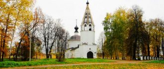
Lighthouse
Photo: Yandex map
It has developed transport links. There are almost no new houses here; for the most part, real estate is represented by five-story buildings and the private sector. There are plenty of preschool institutions, as well as cafes and shops, but there is almost no place for children to go out - if there are playgrounds, they are in unusable condition. To purchase an apartment you will need at least 2.35 million rubles.
Neighborhood
Valley of the Ammonites
Address: between the village. Komennomostsky and the village of Abadzekhskaya
You can get there:
- by car (on the A159 highway);
- by bus from Maykop to the village of Kamennomostsky (the distance from Maykop to the valley is 30 km). From the village - 3 - 7 km on foot.
The Ammonite Valley is an area with shells of cephalopods that went extinct millions of years ago.
The name of the valley comes from the ancient Egyptian god Amun, who had large, curling horns that looked like clam shells.
Some fossils show the relief of spiral shells. The diameter of the shells is from 10 to 20 mm. The largest number of ammonites can be found along the Belaya River (between the village of Tulsky and the Khadzhokh Gorge). It is recommended to start exploring the valley from the bridge over the Belaya River.
The most valuable finds of the ammonite valley are in the “Rock Garden” (Valley Museum). All roads from Maykop to Kamennomostsky pass through this museum. It is not difficult to notice - the building is painted pink.
It is recommended to set aside a whole day to visit the Valley of Ammonites.
Rufabgo stream waterfalls
Address: 3 km from the village of Kamennomostsky Cost : 400 rubles (adult), 200 rubles (children) To get to the waterfalls , you need to drive from Kamennomostsky towards the Lago-Naki plateau until the sign “Rufabgo Waterfalls”. You can leave your car in the free parking lot near the ticket office.
According to one version, the stream is named after an evil giant who lived in these places in ancient times and brought a lot of trouble to the residents of nearby villages. Rufabgo annually took the most beautiful girl in the area and tribute in the form of food and livestock. One day, the brave young man Khadzhokh (the village was named after him) did not want to give up his beloved and decided to defeat the villain. He learned that the giant's chest must be cut with a sword, his heart must be torn out and thrown so far away that no one will find it. The young man did just that. The fallen heart turned into stone, and in this place a waterfall formed, called the “Heart of a Giant.”
In total, there are more than 10 waterfalls on the Rufabgo stream, but only 6 of them can be seen. You can get to the waterfalls for free by moving along the river. However, by purchasing a ticket, you can see the “3 Brothers” waterfall, and also appreciate the beauty of the others from a different angle. Behind the “3 Brothers” waterfall there is a clearing with gazebos, attractions, cafes, and souvenir shops.
Moving along the excursion route, you can visit the Skvoznaya cave, in which, according to legend, the giant Rufabgo lived.
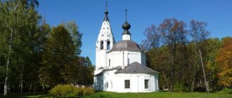
Center
Photo: Yandex map
Five-story houses from the 60s predominate here; sometimes there are two-story ones. There is a central park and Friendship Square, where city festivals are held. There are also fountains and green alleys. The infrastructure is represented by a large market and a train station. In addition, all social organizations are gathered in the central part. Shopping lovers will appreciate the large concentration of shops and brand boutiques. The cost of an apartment starts from 2.5 million rubles.
Sunrise
Photo: Yandex map
Located in the eastern part of the city and is considered a residential area. The real estate is represented by houses from the 70s, mostly five-story buildings, where apartments are valued at 1.9 million rubles. This area has everything you need for life: schools and kindergartens, cafes and shops. Distance from the center can be solved using personal or public transport, which does not pose any difficulties.
Maykop: old town
December 3–4, 2013
I divided that part of the Adyghe capital that I had the opportunity to explore into two halves: old and new. This division is conditional, the locals do not use it, but Maykop is demarcated quite clearly: if the streets lying north of Sovetskaya are much closer in appearance to the Soviet city, then in the southern half of the city historical buildings with several very interesting buildings prevail. There is also a pedestrian street here, so that’s where we’ll start.
The first street you should pay attention to is Pushkina. Its appearance is quite typical: a dense southern one-story building.
There are interesting buildings in it, but sometimes finding them is not so easy. For example, a Roman Catholic church is hidden in this inconspicuous Soviet box. The church was built in 1914, but under the Bolsheviks it was converted into gyms and changed beyond recognition.
On the internet you can find what the church looked like before, but in reality only the roof and a small piece of the old façade sticking out above the socialist walls remained available for viewing.
The neighbors of the church are diverse. There is also an abandoned Soviet building with a powerful portico...
...and a nice, newly built building of the Adyghe State University...
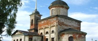
...and another beautiful pre-revolutionary building, a real school building (1900). Now it houses a school.
After the revolution, the eastern wing was added to it, so it looks asymmetrical: on the right we see beautiful masonry and semicircular windows, and on the left there is a dull birdhouse. In addition, the “architects” managed to cram an extra floor into the same height of the building.
Nearby there is a small monument to Lenin, not the most important one in the city.
Ilyich looks at the beer territory class=”aligncenter” width=”1080″ height=”720″[/img]
They say that they used to brew excellent beer here, but after the reorganization in the mid-2000s, the quality deteriorated.
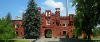
But the new owners reconstructed the main workshop of the plant. This building was built in 1882, and the history of Maikop brewing began with it.
Judging, again, from old images, it was restored very well, and a hotel was opened in one of the expanded side wings. Unexpectedly expensive and good.
The Republican Clinical Hospital was apparently also recently renovated.
Wide sidewalk of Pushkin Street.
The street is named after the poet, obviously, because of the Pushkin People's House built here in 1900. In 1936, the Russian Drama Theater was formed there, also bearing the name of the poet. The building was seriously damaged during the war, so after restoration, instead of a pair of turrets, it received a more typical appearance for the Stalin era, and at the same time a bust of Pushkin in front of the entrance.
Immediately after the theater, the City Park begins.
The park is clean and pleasantly well-groomed: tiles, benches, trimmed greenery. There are also attractions and a couple of statues with local historical figures.
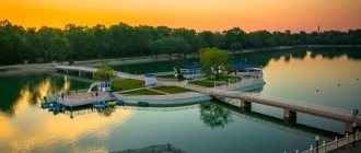
Well, in the center there is a light and music fountain. Of course, I didn’t work in December.
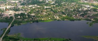
The fountain stands on the edge of the valley, and below flows the small White River (not to be confused with the Ufa Teska), barely visible under the pedestrian bridge. The empty space in the foreground with a pillar in the middle is a public swimming pool. I swam and went to the park. Cool?
Even further to the left is the dam and spillway of the Maykop hydroelectric power station. In comparison with the small Mainskaya hydroelectric station I had seen before, the Maikopskaya hydroelectric station is very small and unproductive (9.44 megawatts versus 321). But it’s worth considering that she is thirty years older (1950), and Belaya is far from Yenisei. Overhanging the dam is Tsarskaya Hill, just over 300 meters high.
We return to Pushkin Street to find another piece of the old brewery - a magnificent malting shop (1900s).
I also like the more typical industrial architecture of the early 20th century, but here it’s a real treat to the eye: every brick is in its place. This is the most beautiful building in the whole city.
Judging by its appearance, it is used, but I don’t know in what capacity. There is parking in the backyard.
We have already turned onto Lenin Street, going north. Here it is poor in attractions and generally does not fit into the main street of the city. In addition to a couple of mansions that were included in the previous part of the story, the only thing that can be noted is the new building of the Investigative Committee. Nice classic shape, just needs some plastering.
If you turn from Lenin onto Komsomolskaya, you can find a nice Stalinist building...
...and the building of the primary school (1910), which now trains medical workers (you can see them in the window). A very typical house for Maykop.
Pervomaiskaya Street, which runs parallel to Pushkin, looks much more interesting. In its western part there is the North Caucasus branch of the Museum of Oriental Art. It opened in 1995; the building is also based on a house built in the early 20th century (the façade on the left appears to be original).
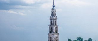
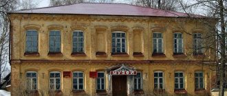
Even further, in another beautiful brick building (1883), the first post office of Maykop was once located. The same building is shown in the title photo.
Today it houses a lyceum, which has acquired a new building.
The urban part of Maykop ends approximately here (in the “horizontal” direction). All beauty becomes one-story.
And then it will be replaced by the typical private sector.
(If you walk long enough in a western direction, you can stumble upon the Holy Trinity Cathedral. I saw it the day before the walk from the car window - I wasn’t impressed, so I didn’t go see it a second time.)
Southern cities have their own, very recognizable comfort. There's a lot of it here.
Let's go back a couple of blocks, to the city part. Here Pervomaiskaya has a completely different look.
But first I’ll show you the Maykop pedestrian. It is called Krasnooktyabrskaya Street (yes, all the names here are Soviet) and starts from the city park. The street owes its first name to him - it was once called Sadovaya.
In the first block of the street, two buildings can be noted. Mayor Ivanov, who was in charge of Maykop in the 1900s, lived in this mansion:
On the contrary, in 1908, a building was built that housed, as in neighboring Krasnodar, a cinema (“electrobiograph”) and a roller skating ring. This establishment was called “Pantheon”, and it received its modern name “Giant” in 1921. Now officially this is the City House of Culture, although films are still shown under the old sign.
Near the cinema there is a nice monument to the local writer Kerashev.
At the intersection with Pervomaiskaya there are three interesting houses (this is generally the most expressive intersection of Maykop). The house of another mayor, Zinkovetsky (or Zinkovetsky, wherever) built in 1907, is occupied by the House of Officers.
Across the road is beautiful early Soviet housing.
And on the other side of Pervomaiskaya there is the Kaplanov trading house (1900). From here the street becomes a carriageway.
This family also had an apartment building here. It was built in 1912, when Sadovaya was already called Ofitserskaya (having managed to visit Telegraphnaya in the meantime).
The building has been rebuilt many times and already looks a lot like the Stalinist building opposite.
The Maikop Hotel is located in the income area. The rest of the street development is visible in the photo and is not of particular interest. Not bad for three blocks, though.
On Krasnooktyabrskaya, as it should be on a pedestrian street, there are several cafes and restaurants. In general, the street is no frills, but quite neat and pleasant.
We head further east along Pervomaiskaya past the city court...
...to another notable old building - the former Altshuler pharmacy (1889).
There is a retail store attached to the side. I didn’t find any information, maybe it’s a remake.
Further blocks are occupied by students: here are the Maykop State Technological...
...and the already mentioned Adyghe State University.
Between them stands a fire tower (1900).
And then the one-story building begins again. Thus, we crossed the multi-storey center of Maykop from east to west and back: its length was about a kilometer.
In the direction from north to south, “urban” Maykop is a little larger - about two and a half kilometers. A quarter of the distance is covered in this report.
The rest, newer part of Maykop will be covered next.
Whole series:
Part 1: introduction → Part 2: old city Part 3: new city