Conventionally, the city can be divided into two parts - Old and New Kamensk. In the old part of the city there are many buildings of the 19th century, the residence of Bishop Kamensky, and a monastery.
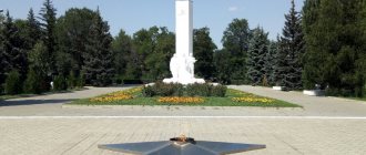
In the historical center you can see the dam, built at the beginning of the 18th century, and one of the symbols of the city - the monument to A.S. Pushkin. A time capsule with wishes for future generations was laid on Cathedral Square.
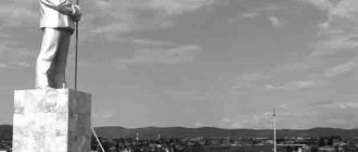
In 1967, according to the design of the architect Permyakov, the Cannon monument was built, which became a symbol of the city. The monument was erected on the left bank of the Kamyanka River in honor of the first workers of the iron foundry. The monument offers a beautiful view of the architectural ensemble of old Kamensk and the dam.
Visit the museum in the steel mill control building. The architectural monument in which the exhibition is located is more than a hundred years old.
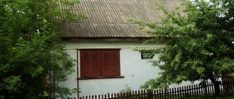
On Lenin Street there are several merchant estates dating from the second half of the 19th century. The buildings are distinguished by their original style and interesting facade design.
“Brick style” and Baroque were used. Decorative elements inside the buildings have been preserved, and many details of the furnishings of those years have been restored.
- Estate of the Zyryanov merchants. St. Lenina, 100.
- The estate of the Shamarin merchants. St. Lenina, 91.
- Estate of the Vorobyov merchants. St. Lenina, 127.
The Tronin House is another attraction on Lenin Street. The ancient mansion was built in the Gothic style with Art Nouveau elements.
Address: st. Lenina, 113.
At 36 Krasnykh Orlov Street there is an architectural monument of the 19th century. The residential building has an unusual pentagon shape.
Bridge over the Sinara River
The first stop is at the ancient stone bridge over the Sinara River still within the Chelyabinsk region .
It’s a mystery to me: how does all this hold up?!
For us geologists, the main value of the bridge is that it is made of granite with oxidized pyrite crystals.
Wonderful place...
Kamensk-Uralsky
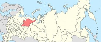
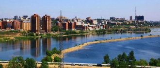
You need to carefully prepare for a trip, especially if you are going to visit an unusual place. And the city of Kamensk-Uralsky is unusual. Kamensk-Uralsky. City in the Sverdlovsk region. Now the city's population is 172 thousand people; in the last years of the USSR, the number reached 210 thousand people. There are many attractions for travelers in Kamensk-Uralsk. Kamensk-Uralsky is the southernmost city in the Sverdlovsk region, its natural landscapes are unique and unusual. On the territory of the city there are both natural and cultural monuments.
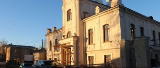
click to enlarge
The historical landmark of the city is its old part. The old city was built at the confluence of the Kamenka and Iset rivers. This area was rich in iron ore, so in 1682 the Dalmatovo Monastery asked for these lands, settled its serf workers there and began smelting iron for its own needs. In 1701, by decree of Peter 1, the factory lands were returned back to the treasury. The first iron foundry in the Urals is being urgently built, and it is given the name Kamensky State Iron Foundry. The history of the city begins. The settlement is growing and developing. Like all cities in the Urals, the city of Kamensk lives entirely to meet the needs of the plant. In 1774, the city was captured by Pugachev troops led by Ataman Chir. A log in the old town is named after this event. It was in this Chirovsky ravine that a detachment of Kasli rebels numbering 500 people under the command of Chir stood. The city began to grow rapidly in 1825, when the chief architect of the Ural factories, M.P. Malakhov reconstructed the plant. In addition to new factory facilities, the following were built: a factory administration, warehouses, a hospital, and the main temple of the city was rebuilt. These old buildings and others built later constitute the main attractions of the old city. You can view them in a few hours, everything is located compactly in one place. It will take more time to explore the natural attractions of Kamensk-Uralsk, not even a single day. These are the amazingly beautiful banks of the Iset River with numerous rocks, caves, grottoes, and suspension bridges.
We have developed a route for visiting the sights of Kamensk-Uralsk. We recommend starting your exploration of the city with natural attractions in order to feel the grandeur and beauty of the Ural nature and better understand the history of the city and its inhabitants. The border between the Urals and Siberia runs right through the city. Most of the city, including the Old Town, is located in the Urals, and the main part of the Sinarsky urban area already lies on the Siberian platform. Thus, Kamensk-Uralsky is the gateway to Siberia; a highway leading to the Trans-Urals, to Kurgan, through the ancient cities and villages of Kataysk, Dolmatovo, Shadrinsk and further through the territory of Northern Kazakhstan to Omsk, Novosibirsk, Altai passes through the city. Travelers from the European part of Russia through Kamensk-Uralsky also enter Central Asia - through Kurgan, Astana and further to Almaty, Tashkent, Samarkand, Bukhara, etc. Now this is one of the most convenient and comfortable travel routes to Asia.
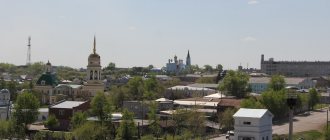
City center. Click to enlarge.
What can a traveler see in Kamensk-Uralsk?
Rock "Stone Gate" on the Iset River
It’s better to start with the most beautiful attraction - the Stone Gate rocks. It is a large rock mass with a large hole in the middle.
It is better to look at the rock from the opposite bank from the territory of the Sosnovy Bor boarding house. But to do this you need to go down the territory to the shore of the Iset. And from the observation deck you can see another natural monument - the Three Caves rock.
It's great to walk along the path along the coast, very beautiful rocks.
Boarding house coordinates (parking): 56°24'34.13″N 61°52'13.58″E
But it’s also a good idea to move to the opposite bank of the Iset to visit the “Stone Gate” rock itself. If you climb the Stone Gate, the photographs will be original, because... The rock is rarely photographed up close, and you will visit the most beautiful landmark of the city. To do this, you need to drive through the road bridge over the Iset River: Coordinates: 56°23'59.89″N 61°55'54.68″E
And go back to the west, along the other side of the Iset. Rock coordinates: 56°24'19.43″N 61°52'24.89″E
The “Stone Gate” rock on the Iset River is one of the calling cards of the city of Kamensk-Uralsky and a most beautiful natural creation. Viewing the rock from both banks, you will pass through the old part of the city. The main attractions are concentrated here. We move along Lenin Street.
Dam on the city pond
Coordinates: 56°25'11.52″N 61°53'25.64″E This is one of the oldest monuments in the city. The dam on the city pond was built in 1701. Since then, it has been reconstructed many times, and today the retaining wall of the 19th century on the right bank of the bridge remains. The pond, formed by a dam on the Kamenka River within the city of Kamensk-Uralsky, was a source of energy for the Kamensky state-owned plant. The dam and the retaining wall of the dam made of rubble stone are architectural monuments of regional significance. The monument is old and valuable, but the abundance of garbage spoils the entire attraction. The section of the left bank of the river below the dam represents outcrops of rocks from different historical eras and is called the “Karpinsky Trail”. The following natural monuments are located on the banks of Kamenka:
Devil's Finger Rock
Devil's Finger Rock
Coordinates: 56°25'58.09″N 61°52'11.85″E
An original columnar rock made of dark limestone on the left bank of the Kamenka River. The rock is connected to the shore by a natural narrow bridge. The remains of ancient marine fauna are clearly visible on the isthmus. Located among picturesque areas of rocky slopes with populations of rare and endangered plants. Nearby there is a small through cave. It is a botanical and geomorphological natural monument.
Transfiguration Monastery
Coordinates: 56°25'18.73″N 61°53'38.88″E
Having passed through the dam, we find ourselves at the Transfiguration Monastery. The Transfiguration Monastery began its history with a women's community, which was founded by Avdotya Voronina in 1862. Before the revolution, 30 nuns and 150 novices lived in the monastery. Later the monastery was closed, and its temples were desecrated and looted. In 1998, on the site of the already destroyed convent, a new monastery was founded, now for men. Now the monastery has been revived. The “Sobriety” society and an Orthodox school operate at the monastery. Calm, pleasant place. We return through the dam. Next to it, on the right bank of the Kamenka, is the old city square. There is convenient parking and many attractions.
Museum of Local Lore
Coordinates: 56°25'6.83″N 61°53'33.14″E
The local history museum in the city of Kamensk-Uralsky was founded in 1924. The museum is located in the building of the former Kamensky iron foundry, built in 1825 - a monument of federal significance, the creation of the architect Malakhov. You will see ancient written sources, a unique collection of music boxes from the late 19th century, a large collection of coins from the Yekaterinburg Mint, a complete collection of rocks from the Urals and local Sinara agates. A collection of paintings by the artist I.K. Slyusarev is also presented here. Among the main excursions of the Museum of Local Lore, the following can be noted: “History of Kamensk of the 17th-19th centuries”, “Collection of furniture of the 19th - 20th centuries”, “Ancient Ural”, “Interior of a factory worker’s hut and a merchant’s shop of the late 19th - early 20th centuries”, as well as - “animals of the native Urals.”
Warehouse premises of the former Kamensky plant, old Drama Theater
Coordinates: 56°25'6.25″N 61°53'40.46″E
Warehouse premises of the former Kamensky plant. The building was built in 1828 - 1829 in the classicism style. Before the October Revolution of 1917, the supply warehouses of the Kamensk Iron Foundry were located here. During Soviet times, this building was occupied by the Kamensky Drama Theater. Currently the building is in need of reconstruction.
Cathedral of the Holy Trinity
Coordinates: 56°25'3.02″N 61°53'33.77″E
Built in 1808 according to Malakhov's design. The temple is considered a symbol of Kamensk-Uralsk. It was originally built as a parish church with a Lower Church in honor of the Life-Giving Trinity. Later the cathedral was expanded. The new bell tower is decorated with huge arched windows and a Corinthian rotunda with a spherical dome. The bell tower is completed by a tetrahedral obelisk. After the revolution, it was also destroyed and looted. In 1997, its revival took place. On the adjacent Cathedral Square, there is a Time Capsule for future generations. We go south from Cathedral Square to a beautiful bright blue temple.
Church of the Intercession of the Mother of God
Coordinates: 56°24'42.11″N 61°53'39.78″E It was built in 1883 at the city cemetery, which was destroyed during the Soviet years. The church is a brick single-altar church with a hipped bell tower, a rectangular two-height quadrangle, which is completed with a small five-domed dome. Services in the temple resumed in the 1990s. Today the church has an iconostasis, ancient and modern icons. The Church of the Intercession of the Mother of God is a real decoration of the city and an architectural monument of regional significance.
Bell factory of Pyatkov and Company
Bell Factory of Pyatkov and Company
Nearby, 150 meters away, is the Bell Factory - the pride of the city.
bell factory of Pyatkov and Company
bell factory of Pyatkov and Company
Kamensk-Uralsky, st. Revolutionary, 49-a. Phones: (3439) 34-34-34, 36-47-47, 37-99-55, fax. E-mail: [email protected] Website: www.pyatkov.ru founded in 1991. The main co-owner and manager of the company is Nikolay Pyatkov. The plant has produced hundreds of bells for Russian churches; this is the most important bell production in Russia. Thanks to the plant, an interesting bell ringing festival is taking place in Kamensk-Uralsk. There is a bell museum at the factory; tourists are taken to the museum and to the production site. A must visit!
The second such production is located on the Volga in Tutaev, but the Tutaevsky plant is much smaller and there is no museum there. Cannons greet visitors at the entrance. And even though they are without carriages, the date cast on them - 1733 - evokes respect. These are trunks from the batch that was cast for the Second Kamchatka Expedition of Vitus Bering.
rocky shore
Coordinates: 56°24'28.30″N 61°53'27.56″E Here, next to the bell factory, the Iset coast is picturesque with its rocky outcrops. Great views of the river.
Old bridge over Kamenka
Coordinates: 56°24'56.57″N 61°54'2.70″E The Kamenka River flows into the Iset within the city. The bridge over Kamenka will amaze you with its monumentality. It has two spans, which are made in the form of arches, resting on coastal abutments and a common central pylon. Made from blocks of gray granite with a roughly chipped surface. Gloomy and fabulous at the same time, the bridge is given a fabulousness by the lush vegetation along the banks of the river. The bridge was built in 1903, the architectural style is neoclassical combined with elements of the “brick style”.
There are also monuments in the Old Town:
- Gostiny Dvor, building 1820 (Lenina St., 118, 120; Revolyutsionnaya St., 2).
- Hospital of the Kamensky Plant, building in 1826 (Krasnykh Orlov Street, 4).
- Gerasimov's shop, built in 1846. The merchant's shop was located on the first floor, and the second was intended for the family. (Lenin St., 124)
- The estate of the Shamarin breeders, built in 1852 (Lenin St., 91).
- Men's school, building in 1856 (Lenin St., 128).
- Bukharev's manufacturing store, built in 1867.
- Factory School, built in 1868 ((Karl Marx St., 17).
- The estate of the plant caretaker, built in 1873 (Lenin St., 119).
- The estate of the merchant Vorobyov, built in 1889 (Lenin St., 127).
- Shop of the Molchanov merchants, built in 1893 (Lenin St., 103-A).
- Estate of the Zyryanov merchants, built in 1898 (Lenin St., 102).
- House of the Grachev merchants, built in 1907 (Lenin St., 108).
- The railway bridge over the Iset River, built in 1939, architect V. A. Rosnovsky, is a unique single-arch bridge in Russia made of steel pipes filled with concrete, its height is 140 meters, and is a cultural monument of regional significance.
After the bridge we find ourselves in the modern part of the city.
Chapel of Alexander Nevsky
Chapel of Alexander Nevsky
Coordinates: 56°24'51.15″N 61°55'3.90″E
The Alexander Nevsky Chapel was built in honor of the celebration of the 300th anniversary of the city on the central square of Kamensk-Uralsk according to the design of the architect A.V. Dolgova. In 2001, the chapel was presented with an icon of Prince Alexander Nevsky. Currently, the chapel is a landmark and symbol of the city. The annual Russian Bell Ringing Festival takes place on the square in front of it.
Well, we've seen the main attractions. But if you examine everything to get to know the city of Kamensk-Uralsky and its surroundings properly, it will take more than one day.
Other monuments
FD series steam locomotive
FD series steam locomotive
The landmark of the city station is the FD series steam locomotive (“Felix Dzerzhinsky”), they were produced in 1931-1941. The locomotives of this series were the most powerful mass-produced locomotives in the world. The monument to the steam locomotive is located near the railway station on a special site. Address: Station Square
Monument Cannon
Monument Cannon
The monument, which was also declared a symbol of the city. Next to the monument there is a bas-relief dedicated to the War of 1812. Located in the Sinarsky district, on the left bank of the Kamenka River, next to the Dam.
Elk on the bank of the Iset River
Elk on the bank of the Iset River
Coordinates: 56°24'1.91″N 61°55'1.25″E A huge iron elk stands on the bank of the Iset River (in the forest part of Kamensk-Uralsky). The height of the monument is about three meters. Now the moose is painted orange. There was a time when it was pink, and even white with black spots.
Rocks “Seven Brothers”, “Mammoth”, “Petit Dru”
Rocks "Seven Brothers"
Coordinates: 56°25'11.11″N 61°49'18.83″E On the banks of the Iset, not far from each other, there are the rocks “Seven Brothers”, “Mammoth”, “Petit Dru”. There are many caves, little caves and grottoes in the rocks. From the top of the Seven Brothers there is a beautiful view of Iset and its surroundings. The ridge of rocks has not yet suffered from the attacks of tourists, although it is located almost on the outskirts of the city. There is a sandy beach a little away. Getting to the rocks is not difficult. You can drive up from any bank. There are rocks here on both sides of the river: opposite the beach there is the “Mammoth” massif, on the same bank, a little upstream, “Petit Dru”. And from the clearing, downstream, there is a view of the Seven Brothers massif. There is a steep descent to the river.
In addition, on the territory of Kamensk-Uralsky there are also very interesting natural monuments, mainly rocks:
- Smolinsky stone
- Rastrus
- Three brothers
- Weathering niches
- Owl
- Dinosaur
- Tokarev (Forehead) stone
- Kodinsky warm spring
- Damn steps
- Mount Bogatyryok
Almost all natural monuments are located within the city.
The city hosts the following festivals and events:
- Kamensk-Uralsky is the bell capital of Russia. The annual festival brings together the best bell ringers from Russia and neighboring countries.
- Green Carriage Festival. The traditional art song festival takes place on the third weekend of August.
- Kamensk-Uralsky carnival. Held every five years, on the city's anniversary. Costume procession.
- World Motocross Championship. Has been running since 2011. Athletes come from Great Britain, Finland, Latvia, France, the Netherlands, Belgium, Sweden, Germany, the Czech Republic, Ukraine, Estonia, Switzerland and Russia.
On the Kamenka and Iset rivers within the city there are several suspension bridges, or as they are called in the Urals: Suspension Bridges , walking along which is both scary and exciting.
Other photos of Kamensk-Uralsk:
Kamensk-Uralsky and Scala Stone Gate
NUDE #4
In the place where the Kamenka River turns south, outcrops of loose clastic rocks appear on its steep slopes, and another magnificent panorama opens to the inquisitive eyes of interested observers for studying the geological history of the Earth. We are talking about the so-called “weathering crust”, which looks most impressive in the deep ravine going down to the river from Kunavina Street.
This nameless ravine literally cut through the thickness of multi-colored clays. If here, in the ravine, they have a gray, red, purple and brown color, then in the area of K. Marx Street, seemingly nearby, there are already clays of other colors - light yellow and white. Clays contain a large amount of crushed stone of various types. Unlike limestone and coal-bearing rocks crumpled into folds, variegated clays lie horizontally, which is easy to notice if you look closely at the layers of crushed stone.
They were formed as a result of the intense destruction of sedimentary and igneous rocks of the Paleozoic mountains during the Mesozoic era, when the climate on our planet became very hot and humid. The processes that led to the emergence of the “weathering crust” are also associated with the formation of deposits of brown iron ore and bauxite. For the needs of the state-owned iron foundry, until 1917, we developed numerous deposits of iron ore, individual nests of which were discovered north of the river valley, where Pobedy Avenue now stretches, as well as in three mines located near the mouth of Kamenka: Razgulyaevsky, Zakamenny and Polyaninovsky.
The “weathering crust” rocks were formed in the first half of the Cretaceous period of the Mesozoic era, approximately 140-100 million years ago.
Reflecting on the geological past of our region, we are forced to admit that even today not all of its pages are easily explained and understood without any reservations. If the Kamensk limestones are 320 million years old, and the clays are 140-100, then why don’t we find any other rocks of intermediate age? The huge chronological gap most likely resulted from the fact that there was no accumulation of sedimentary rocks here for a long time. The course “Historical Geology” gives, for example, the following answer to the question. Over the course of 65-70 million years, mountain ranges slowly rose up on the site of the current West Siberian Lowland and the Urals. It took another 90 million years for the once high (like the modern Caucasus) Ural mountainous country to be destroyed and turned into a plain by the sun, water and wind. Therefore, the entire West Siberian Lowland is composed of sands and clays formed as a result of the processes of weathering and washing away rocks of ancient ridges.
The roots of these mountains that disappeared from the face of the Earth, exposed by the valleys of the Iset, Kamenka and Kamyshenka rivers, are what we see today, surveying the surrounding area and natural monuments of our native land.
Nikolai Pyatkov Bell Factory
Most tourists have never been to the workshops of an enterprise that produces bells. This enterprise is the only one in the Urals that specializes in the production of such unusual products.
Craftsmen make bells weighing from 90 to 1140 kg. “Crimson Ring” has been born in Kamenets-Uralsky for more than 20 years.
Due to the massive construction of temples and churches, there is always a demand for bells of different sizes. A tour of the bell factory workshops will certainly be memorable for guests of Kamensk-Uralsky.
The history of production began in 1990. Only a few years passed and the bells cast in Kamensk-Uralsky earned many positive reviews from the abbots of the monasteries and the highest clergy. Even St. Basil's Cathedral in Moscow and the Donskoy Monastery have bells made by Ural craftsmen.
Address: st. Revolutionary, 49a.
Natural attractions
Rock Stone Gate
A 20-meter-high natural creation is located on the banks of the Iset River. It was first described by the historian N. Popov.
The only rock in the city recognized as a monument of regional significance! The arch was formed as a result of the gradual destruction of limestone rock.
On the rock you can see ancient fossils - sea lilies, corals. Local residents consider this place to be the entrance to the world of the dead, but there is no explanation for this. A former resident of the Martyush settlement wrote in her diaries that almost every year people, mostly children, died on the rock.
The arch gradually goes under water, as can be seen from old photographs.
Threshold Howler
The threshold got its name because of the noise it makes, similar to a roar. The length is approximately 300 meters, the river bed is strewn with large boulders.
On one of the rocks surrounding the threshold, archaeologist V. Bushuev discovered the remains of petroglyphs.
In spring and summer, kayaking takes place on the rapids, rafting competitions take place, and climbers conquer the rocks.
Kodinsky warm spring
A unique natural creation - here, clean water always flows from a fault at a temperature of 18 degrees, and even in winter green grass grows around the spring.
The depth of the crack is more than 600 meters. The key contains the rare gas radon, and there are only 300 similar sources in the world.
You can drink water from the spring only after settling.
The spring is too small to build a resort, although local residents believe that the water from the spring cures heart disease. Previously, people used to wash and bathe in the spring.
Fox Mountain
The main attraction of the city. There are no reliable versions about its name. It is assumed that foxes once lived at its foot; according to another version, the smoke from factory chimneys resembled fox tails. It is widely believed that the original name of the mountain was Lysaya, since nothing grows on it. And subsequently the word acquired a romantic connotation and was transformed into “Fox”. Local historians are scratching their heads while discussing the essence of the name. But Fox Mountain is notable not only for discussions about its origin. There is a tower at the top of the mountain. Built in the 19th century, it raises many hypotheses about its purpose: watchdog, fire, meteorological, a romantic symbol of love between Nikolai Nikitich Demidov and his wife Elizaveta Alexandrovna (nee Baroness Stroganova). After decades of neglect and destruction, the tower was restored and now houses the smallest museum in Russia. Its exhibition is dedicated to the complex family life of the Demidovs. From the top of the mountain there is a beautiful panoramic view of the city.
Vayner Street
Vayner Street, located in the central residential area of Yekaterinburg, is called by local residents the Ural Arbat. The oldest street in the city before the revolution was called Uspenskaya. It has always been a center of activity and trade. And now the tradition has not died out. Large shops, popular hotels and restaurants are located here.
The beauty of Weiner Street is that it is pedestrian. Cars will not prevent you from enjoying your walk. The Ural Arbat is completely filled with architectural monuments. These are ancient private mansions and enterprise buildings of past centuries. The entire alley is decorated with original modern sculptures.
NUDE #5
In the upper reaches of the ravine, under modern loams, greenish sands were exposed. At the end of the Cretaceous - beginning of the Paleogene periods, our area, like the entire eastern slope of the Ural Range, sank again, turning into the seabed. The depressions of the Mesozoic relief were filled with new sediments: clays, siliceous rocks - opoka and sands. Greenish glauconitic sands are 60-40 million years old. The sea, which rushed here from Western Siberia, left another reminder of itself - white quartz sands. Occurring in the area of the Silicate village, the villages of Kodinka and Pirogovaya.
It is amazing that the huge ravine owes its birth to a modest spring, which hardly makes its way to the surface from the aquifers of the earth.
NUDE #2
Downstream the Wheatear, limestones are replaced by other rocks: sandstones, clayey and carbonaceous shales, and conglomerates. All these rocks have a dark brown, and in some places black, color, and therefore differ sharply from gray, and almost white at the surface, limestones. They are classified as the Kamensk coal-bearing strata of the Carboniferous system. Since they are 10-15 million years older than limestones, then, in theory, they should lie underneath them. But mountain-building processes turned them out from under the limestones and crushed them into folds.
Sandstones and shales contain charred remains of ancient plants: tree-like horsetails, club mosses and ferns, which became the starting material for the formation of coal. Here, on the left bank of Kamenka, one of the coal deposits was discovered at the beginning of the 19th century. The continuation of the coal strip opposite the village of Brod was developed from the 19th century to the mid-20th century. Geological exploration discovered 14 coal seams, three of which with a thickness of 0.8-1.2 m later turned out to be quite productive.
The rocks of the coal-bearing strata are witnesses of the Early Carboniferous era (335-320 million years ago). Then, on the swampy land of one of the many volcanic islands of the ancient Ural Sea, forests rose in which 30-40-meter calamites, sigillaria and lepidodendrons grew.
14 layers of coal interlayered with sandstones and shale are the best evidence of how forests grew and died at this place at least 14 times. They were covered by sedimentary rocks - sands and clays - when sea levels rose and fell. And later they were covered by a thick layer of limestone, which was described above.
Traveling around Iset
If you take a ride around Iset on a water bus, you can see three interesting objects at once.
Arched railway bridge "Butterfly"
This is an amazing single arch railway bridge. It was designed by Moscow engineer V.A. Rosnovsky. back in the late 1930s. Metal pipes with a diameter of 0.9 m are filled with concrete. This technology was no longer used in bridge construction. Included in the register of architectural monuments of the Soviet period.
Sculpture "Moose"
This moose appeared in the mid-1980s. The art object is located near the confluence of the Kamenka and Iset rivers. Author: Vladimir Permyakov.
Rock "Stone Gate"
A rock 20 m high with a through arch. A natural monument of regional significance, included in the list of specially protected areas in Russia.