By the beginning of the 21st century. Almost half of the population of world civilization lived in cities. Cities play a leading role in the economic, socio-political and socio-cultural life of countries and peoples of the world. Cities produce 4/5 of the value of all goods and services produced in the world. Thus, modern world civilization is, first of all, an urban civilization. The main direction in the development of society is its urbanization. The peculiarities of the concentration of population and economic life in cities, the spread of their influence on the agrarian environment constitute the core of the historical process in Modern and Contemporary times. Understanding the essence of modernization of society is impossible without identifying the main stages of urbanization.
The cities of the Urals occupy a special place in the history of Russia. And today they play an important role in the economic, socio-political and socio-cultural development of the country.
Of the 1040 cities in Russia, 140 are located in the Urals, of the 13 million-plus cities, 4 are Ural cities (Ekaterinburg, Perm, Ufa, Chelyabinsk).
How did the formation of the Ural cities proceed in historical dynamics? Their formation and development can be divided into three large stages. The first covers the pre-industrial era (XV-XVII centuries), when 33 cities arose in the Urals1. At the time of their formation, these were mainly settlements, small villages and fortresses, which became an outpost for the development of the vast expanses of the Urals and Siberia, and did not play the role of industrial and administrative centers.
The second stage of urbanization of the Urals began with the beginning of Peter the Great’s modernization in the first quarter of the 18th century, when such fortress factories as Kamensk-Uralsky, Nevyansk, Yekaterinburg, etc. were founded. This stage continued until the start of capitalist modernization of Russia in the second half of the 19th century. It turns out that such cities make up the majority in the Urals. There are 73 of them, and 65 of them arose in the 18th century. These were mainly factory cities, where the industrial power of the “backbone of the state” was built.
The third stage of development of the cities of the Urals, urbanization of the region covers the period from the last third of the 19th century. until the end of the 1920s. This is the era of capitalist modernization of Russia, wars, revolutions, restoration of the national economy, the eve of the “Stalinist industrial revolution.” At this stage, 16 new cities arose on the map of the Urals, the birth of which is associated, as a rule, with the development of new mineral deposits (for example, Asbest, 1889), the construction of a railway (Bogdanovich, 1883) or the construction of new large factories ( Serov, 1899).
Of course, the process of urbanization in the region accelerated sharply during socialist industrialization. However, few new cities emerged in the “Stalin era,” as in the subsequent decades of Soviet power. From the late 1920s to 1989 15 cities2 appeared on the map of the Urals, starting with Magnitogorsk in 1929 and ending with the city of Dyurtyuli (Bashkortostan) in 1989. All of them, with rare exceptions, arose as a result of the development of newly discovered mineral deposits (for example, Kachkanar, 1956) or the construction of new large industrial enterprises (Magnitogorsk, 1929). The process of urbanization of the Urals in the twentieth centuries. was mainly due to the growth of the population of cities that arose in the pre-industrial era (XV-XVII centuries) and during the period of pre-capitalist modernization of Russia (XVIII - first half of the 19th centuries).
When did the economic and geographical location of the Ural region become advantageous?
4 A lion is more / most dangerous than an elephant. The economic and geographical position of the Ural region 1) became advantageous in the 20th century.
Interesting materials:
How to abbreviate a subparagraph correctly? How to correctly abbreviate words in Russian? How to draw up a contract for the provision of services? How to correctly draw up an additional agreement to a supply contract? How to draw up a preliminary contract for the purchase and sale of a house? How to correctly draw up an order for the main activity? How to correctly create a production characteristic? How to create a daily routine for a schoolchild? How to correctly draw up an invoice for an advance payment? How to correctly outline a complex sentence?
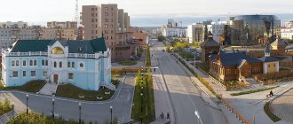
Ufa
- Population: 1,124,226 people (2019)
- Founded 1574
The capital of Bashkortostan, the largest oil refining center in Russia, an important transport hub. Multi-faith religious center.
The millionaire city of Ufa is the most spacious in the Russian Federation; in 2010, there were 698 m² of urban territory per resident.
In 2015, Ufa is scheduled to host the BRICS and Shanghai Cooperation Organization summits.
Ufa took 2nd place in terms of living comfort according to the integral rating of the 100 largest cities in Russia in 2012; and 2nd place according to the Forbes rating “The best cities in Russia for business - 2012”.
The city lies on the Pribelsky ridge-undulating plain, 100 km west of the ridges of the Southern Urals, on the banks of the river. Belaya, with the river flowing into it. Dema and Ufa. Mainly located on the Ufimsky Peninsula, between the Belaya and Ufa rivers. The city is 53 km long - from north to south, 28 km - from west to east.
Ufa is the 3rd longest city in the Russian Federation (Sochi and Volgograd).
Interesting facts about the Urals
Some interesting, but little-known facts about the Urals:
- The Ural Mountains have a length of more than 2 thousand km.
- At their narrowest point, the Ural Mountains are approximately 40 km wide, and at their widest point, about 150 km wide.
- In geographical terms, the Ural Mountains belong neither to Europe nor to Asia, but act as a natural barrier and border between these parts of the world.
- Ancient geologists believed that there was nothing beyond the border of the Ural Mountains, and that the mountains themselves were the border of the world, the edge of the world.
- The oldest mountain on Earth is Mount Karandash, it is part of the Ural ridge, and its age is at least 4.2 billion years (the age of planet Earth is 4.6 billion years).
- The Ural Mountains pass through all climate zones, excluding deserts and semi-deserts.
- From malachite mined in the Urals, bowls were cast in the Hermitage in St. Petersburg and the interior of the altar of the Church of the Savior on Spilled Blood was decorated.
- In Bashkiria there are ancient coral reefs (Sterlitamak shikhans), which formed in the Perm Sea about 230 million years ago, and they look like cone-shaped hills.
- It was in honor of the Ural Mountains that a motorcycle, a guitar and a truck were named.
- Sugomakskaya Cave is the only marble cave in the Urals, its length is 123 m.
The Urals are not the only rich region located on the map of Russia, but the fact is undeniable that few regions can compare with it in terms of the number of picturesque places and mineral resources, majestic mountain ranges and diversity of flora and fauna.
Author: Ekaterina Pestova
Article design: Oleg Lozinsky
Magnitogorsk
- Population: 416,521 people (January 1, 2022)
- Founded 1929
The city of the Chelyabinsk region of the Russian Federation, one of the largest centers of ferrous metallurgy in the world.
Magnitogorsk is 420 km away from Chelyabinsk by rail, 308 km by road, and 321.4 km from station to station by highway.
The territory of Magnitogorsk is 392.35 km², length 27 km from south to north, 22 km from west to east, 310 m altitude.
The western border of Magnitogorsk is the administrative border of the Chelyabinsk region and Bashkortostan.
Magnitogorsk is located at the foot of the Magnitnaya Mountain, on the eastern slopes of the Southern Urals, on 2 banks of the river. Ural (right coast of Europe, left coast of Asia). The city lies on the historical territory of Bashkortostan. It is the 25th city in the Russian Federation by area and 42nd by population.
19th century
At the beginning of the 19th century, under Alexander I, the Perm and Vyatka provinces were united into one governor-general . Tobolsk Governorate became part of the Siberian General Government
In 1802, the Office of the main board of the factories was replaced by the Yekaterinburg, Perm and Goroblagodat mining authorities . In 1806, the country's mining industry began to be managed by the Department of Mining and Salt Affairs , and the power of the Perm Mining Board extended to the entire mining Urals. The Perm governor-general was considered its head, but in fact it was controlled by his assistant, the Perm berg-inspector.
In 1826, Nicholas I established the position of chief commander of the mining factories of the Ural ridge . It became a separate branch of government and was in no way dependent on the provincial authorities. The mining board now reported directly to the mining chief, and the berg inspector became his assistant. The mountain chief had at his disposal the mountain police and three line battalions. The first commanders were generals A.A. Boguslavsky, A.I. Diterichs, V.A. Glinka.
In 1831, the Perm Mining Administration was transferred to Yekaterinburg, and it was renamed the Ural Mining Administration . The Urals were divided into mining districts. Factory offices were subordinate to the district ones. In private districts, the chief commander only monitored compliance with the laws; there his power was not absolute.
In the first half of the 19th century, the vast majority of the population of the Urals continued to be peasants . Most of them were considered owned . They retained personal freedom and bore duties only for the benefit of the treasury. In 1807, the institution of registration was abolished in the Urals. The assigned peasants at the factories were replaced by permanent workers , who were recruited from the same peasants. The peasants had to allocate 58 people out of every thousand. They were required to move to factories and become permanent workers, working at least 10 months a year. At the same time, they were exempt from paying the poll tax. Their sons were also required to work in factories. The factory authorities paid them a salary and provided them with mowing and arable land.
By 1847, a military regime had developed at state-owned factories. Permanent factory workers (craftsmen) were exempt from state taxes and duties, had the right to resign and receive a pension. They left the factory if they were considered “incapable” of factory work or if they had served the required term (25 years, and since 1847 - 35 years). Retirees became personally free people.
There were relatively few serfs On the eve of the abolition of serfdom in 1861, in the Perm province there were 22.4%, in the Orenburg province - 18%, and in the Tobolsk province about 0.3%. Landownership was developed only in the Orenburg province.
In the 19th century, the urban population grew. It is known that in 1795 there were about 59 thousand merchants and peasants in the Urals, in 1811 - 72 thousand, and in 1857 - already about 141 thousand.
The cities of the Urals could be divided into five groups:
- old administrative and shopping centers (for example, Tyumen);
- previously thriving cities that gradually lost their former glory (Cherdyn, Solikamsk, Verkhoturye, Tobolsk);
- growing commercial and industrial centers (Perm, Kungur, Yekaterinburg, Shadrinsk, Irbit);
- young cities, district centers, which actually remained rural settlements (Osa, Okhansk, Kamyshlov);
- southern cities, administrative and military centers (Orenburg, Troitsk, Chelyabinsk, Ufa).
A special place among all the Ural (and, in general, Russian) cities was occupied by Yekaterinburg - the capital of the mining Urals, an industrial, craft and trade center. Having received the status of a mountain city, it did not lose its status as a county center. As a mountain town, it found itself subordinate to the mountain authorities. At the same time, as a county town, it was also under the jurisdiction of the provincial administration. A struggle developed between the mining and provincial authorities, which in 1847 resulted in open conflict. In 1851, power over the city completely passed to the mountain authorities. Local city government bodies (city duma, mayor, magistrate) also depended on them.
In 1865, the Orenburg province was divided into Orenburg and Ufa. Since she was a border guard, she was subordinate not only to the civil governor, but also to the military governor-general. By 1876, the Orenburg province included 5 Ural districts: Orenburg, Orsky, Troitsky, Chelyabinsk and Verkhneuralsky.
At this time, provincial boards , which were divided into departments: administrative, medical, construction, prison, statistical committees, control chambers, etc.
In the second half of the 19th century, provinces were divided into counties , and counties into volosts . The volosts were the lowest administrative unit; they consisted of several rural communities. Thus, the administrative-territorial division at that time looked like this: province - counties - volosts - rural communities.
The district was governed by a police officer . The district was divided into camps headed by police officers . In 1878, the position of police officer , reporting to the police officer. The sergeant had almost unlimited power over the peasantry. That is, the vertical of power in the second half of the 19th century was as follows: governor - police officer - police officer - police officer.
Economic management was carried out by the Ural Mining Board (formed in 1806) and the Chief Director of Mining Plants of the Ural Range (since 1826). The mountain authorities were not subordinate to either the military or civil administration. It had its own police, mountain court, post office, schools, hospitals. The mining industry was managed through state and private districts. They included the factories themselves and the territory allocated to them with forests and mineral resources. In the Urals there were 6 state-owned mining districts with 20 factories. There were more than 50 private districts, in which there were up to 160 factories. In the 1860s, the mining industry was transferred to the civil administration.
In the 1860-70s, new local government bodies - zemstvos - . City councils were elected in cities . According to the regulations of 1864, a new judicial system was introduced. Since 1874, the feudal conscription system of army recruitment was replaced by all-class conscription. The country's territory was divided into 13 military districts . The Urals became part of the Kazan Military District .
Most of the population of the Urals professed Orthodoxy. The territory of the Urals was divided into dioceses : Tobolsk, Orenburg and Ural, Ufa and Menzelinsk, Perm and Solikamsk, Ekaterinburg and Irbit. Dioceses were divided into dean districts, to which parishes were subordinate. The center of the parish was a village with a church.
Historical center - Old Kamensk
Kamensk to this day . Three dozen architectural monuments of regional significance can be found in Old Kamensk . Merchants lived in them, schools, colleges, and shops were located.
Monument "Cannon"
The symbol of the city. The monument is located on the high bank of Kamensky Pond . Created in 1967 and installed for the 50th anniversary of the Great October Revolution. The bas-reliefs of the pedestal depict scenes of military battles in which the Kamensk guns .
Museum of Local Lore named after I.Ya. Styazhkina
Architectural monument of federal significance. The museum is located in the building of the former office of the Kamensky State Iron Foundry , built in 1825. The pride of the museum is the artillery collection, collected from samples of products from the Kamensk plant , starting from 1733.
Dam on the Kamenka River
The first Ural dam is Kamenskaya . It was built in 1700. The above-ground part of the dam is made in the style of Soviet classicism.
Kolokolny
Kamensk-Uralsky bears the title of the bell capital of the Urals . For two decades, bells have been cast in the city for churches in Russia, Europe and America. Our plant is the only one in the country where tourists can see the casting technology inside and out, and finally make a wish by ringing the bell.
Enterprise for the production of bells weighing from 6 to 18 tons. The plant was built according to a special project and meets all European requirements for bell production.
Warehouses – Provision warehouses
Architectural monument of regional significance. The building was created according to the design of Mikhail Pavlovich Malakhov , and was rebuilt twice during the Soviet period, so it has lost its former appearance. It acquired its current appearance in 1958, after its reconstruction by local architect V.A. Gagarin . was located here . CM. Kirov and drama theater .
Sterlitamak
- Population: 278,127 people. (January 1, 2022)
- Founded 1766
A city with republican subordination in Bashkortostan of the Russian Federation, a large regional center, a former administrative regional center. The former capital of the Bashkir Autonomous Soviet Socialist Republic, administrative district center, while Sterlitamak is part of an independent municipal formation of Bashkortostan - the urban district of the city of Sterlitamak. Population 274.38 thousand people, 2012. The second largest population in Bashkortostan after the capital of the republic - Ufa.
The city lies on the left bank of the river. Belaya (Kama tributary).
It is a major center of mechanical engineering and chemical industry.
Sterlitamak is the center of the polycentric agglomeration of Southern Bashkortostan, which has powerful production potential.
Sterlitamak is located in the European part of the Russian Federation, just south of Ufa, 121 km. To the east of the city (about 50 km) are the Ural Mountains, and to the west is the East European Plain. Within Sterlitamak (the valley of the Belaya River) lie the shikhans (Kushtau, Yurak-tau, Shakhtau, Tratau) - these are unique geological natural monuments. Near Mount Kushtau there are children's health camps, holiday homes and ski resorts. Ufa International Airport is located about 100 km from Sterlitamak.
Initially, the city was built between the Sterlya and Ashkadar rivers (historical center, Old Town). Then Sterlitamak was built up mainly to the north and west.
The largest nearby cities are Salavat (26 km to the south) and Ishimbay (21 km to the southeast).
The river flows in the center of the city. Sterlya, it flows into Ashkadar, on the eastern part. Five road bridges and one railway bridge were built across the river within Sterlitamak. In the southeast, Ashkadar is separated by the Zaashkadarye district from the main part of the city. The river is adjacent to the east. Belaya, this is the border between the Ishimbay and Sterlitamak regions of the republic. In the Mashzavod area, in the south, Sterlitamak borders the river. Olkhovka (tributary of the Ashkadar).
Region meaning
It is known that the Ural region is one of the most important centers for the development of many industries. The resources that this territory possesses can serve as a good element for the scientific and technological progress of the entire country. Rich mineral deposits, competitiveness of production, scientific and technical potential can be the basis for the successful development of the Urals.
But the obstacle to this is that now most production facilities are passing into the hands of entrepreneurs. Now the potential of the Urals is no longer aimed at scientific progress, but at working for people. For example, in the Urals in recent years, agriculture, and especially farming, has been intensively restored.
Private entrepreneurship is developing well, providing a large number of people with jobs in the best and most promising enterprises. It is private entrepreneurs who are able to boost the economy of the region, because they have a personal interest in success.
Mining in the mountains is the basis for the development of ferrous and non-ferrous metallurgy, and metallurgy and mechanical engineering themselves are the main areas in terms of the number of products produced.
The Urals also copes well with service production, mining of coal, electricity, and consumer goods. The Urals are the leader in the supply of titanium, magnesium and aluminum. The Urals on the map of Russia are in a very favorable location relative to oil fields. Oil production is carried out mainly in the Orenburg and Perm regions.
Climate
The Urals are remote from the seas and oceans, so its climate is continental. The region is characterized by sharp temperature changes, sometimes even within a day.
This is due to constantly alternating warm and cold air currents. The wind from the Arctic often brings frost, and the dry southern wind brings warmth. The movement of winds from the west is hindered by the Ural Mountains.
The average temperature in winter varies from -17℃ to -20℃. The average temperature in summer is +19℃. There is a lot of precipitation, especially in mountainous regions.
The Urals are located in the following climatic zones:
- arctic;
- subarctic;
- moderate.
Parks, entertainment and more
Ski centers of Ekaterinburg
- GRK "Uktus" - Ekaterinburg, st. Winter, 27/1. There are five ski slopes ranging from 400 to 1200 meters in length. The height difference is from 50 to 100 meters. Equipment rental - from 100 to 500 rubles.
- VGC "ZimaGor" - Ekaterinburg, Sibirsky Trakt, 2. The cost of classes with an instructor will cost from 500 to 14,400 rubles. To ski independently, you need to purchase passes from 3 thousand rubles.
- Mount Deciduous - EKAD, 23 km. Offers 4 tracks with a height difference of 70.5 meters, length from 150 m to 8 km (ski). Rental of various equipment - from 70 to 500 rubles per hour.
- GLC "Park Iset" - Verkhnyaya Pyshma. 3 tracks for skiing, snowboarding and tubing. Equipment rental - from 100 to 1350 rubles.
Hot Springs
- “Baden-Baden Emerald Coast” - Sverdlovsk region, Rezh, st. Lenina, 118. Equipped complex with thermal pools.
- "Spring" - Sverdlovsk region, Tavda, st. Zavodskaya, 80. Hotel complex with an open-air thermal pool.
- “Watercolor” - Sverdlovsk region, Turinsky district, Vodoistochnik village. Mineral hot water was discovered in the 50s. while searching for oil.
- “Baden-Baden Forest Tale” - Chelyabinsk region, village of Etkul. In addition to a swimming pool with mineral water, there are water attractions, recreation areas, and a cafe.
- "Thermal Baths Alexandria" - Chelyabinsk region, village of Pechenkino. The basis of the complex is Lake Gorkoye.
- “Verkhniy Bor” - Tyumen region, Tyumen, 11 km of Salairsky tract, 1. The complex consists of three thermal bowls on the shore of Lake Krivoye.
- “Sosnovy Bor” - Tyumen region, Tyumen, 27 km. Yalutorovsky tract, page 1. Hot spring enriched with minerals.
- "Avan" - Tyumen region, village. Kamenka, st. Mira, 4, building 2. The water temperature in the pools remains at 45 degrees in both summer and winter.
- “Sovetsky” - Tyumen region, Tyumen district, 35 km of the Salairsky tract. The water temperature is kept at 38-46 degrees.
- "Yar" - Tyumen region, Tyumen, Yar village, st. Source, 6, building 1. The closest open-air hot spring to Tyumen.
- "Baden-Baden" - Kurgan region, Ketovsky district, European village. The complex includes a children's and two adult areas. The water temperature does not exceed 40 degrees.
- “7 and I” - Kurgan region, Kurgan, Karbysheva street, 33B, building 2. In addition to hot mineralized water, there are massage facilities.
Mini-zoo "Noah's Ark"
Address: Tyumen region, Ishim, st. Kurganskaya, 83 Phone: +7 34551 2‑63-60, +7 908 870‑32-69 Opening hours: Mon, Wed, Fri, Sat, Sun 13:00-18:00 Cost: 100 rubles
The zoo opened in 2014. The collection of animals is small: a white camel, a tame fox, a mink, several poultry and a pelican.
Almost all inhabitants can be petted or picked up.
Reindeer farm in Visim
Address: pos. Visim, Sverdlovsk region Telephone: Cost: 50 rubles, children under 7 years old - free
The nursery contains sika deer, deer, Yakut horses, goats, pigs, as well as several species of birds.
Animals can be fed: what products can be checked with the farm staff.
If you have not yet chosen where you will live and want to save money when booking, we recommend using the RoomGuru service. Firstly, it contains hotels, apartments and guest houses from many different booking systems, so you won’t miss out on a worthwhile option. Secondly, you can immediately compare prices for one place in different services and book where it is cheaper (this is not always Booking!).
Kurgan (city)
- Population: 315,311 people (2019)
- Founded in 1679 Tsarevo Settlement - until 1738; Kurganskaya Sloboda - until 1782.
Kurgan is a large city in the Russian Federation, the administrative center of the region. Located in the Urals Federal District (Ural Federal District), in the Southern Urals and Trans-Urals, along the banks of the river. Tobol (mainly on the left bank).
Population - 327.9 thousand people, 2012. Area 393 km²
This is an important scientific, cultural and economic center of the Ural Federal District, a major transport hub. Industrial center (military-industrial complex, medium-sized mechanical engineering, light and food, chemical, industry). Kurgan is widely known, as the Russian Scientific Research Institute is located here. Ilizarov. The city also produces the famous KAVZ buses, BMP-3 infantry fighting vehicles, and medicines.
The mound is located in fact in the center of Eurasia, 75 m above sea level. The city lies on the West Siberian Plain. It should be noted that the geographical location of the city is extremely advantageous and has had a positive effect on the development of the city. The main transport routes from the Center of Russia to Siberia (the Baikal federal highway, the Trans-Siberian Railway) run through Kurgan, providing communication between the Asian and European parts of the country.
Reforms of administrative-territorial division
Researcher S.A. Tarkhov identified 13 stages of change in the administrative-territorial division of Russia over the past 300 years:
1) the first Peter's reform of 1708; 2) the second Peter's reform of 1719; 3) transformations of the administrative-territorial structure of 1727; 4) Catherine's reform of 1775; 5) Pavlovsk reform of 1796; 6) restoration of Catherine’s provinces and the formation of new provinces in the 19th century; 7) the formation of a system of administrative-territorial division in the newly annexed and colonized territories (second half of the 19th century); administrative-territorial division of the Russian Empire at the beginning of the 20th century; 9) the existence of old and new administrative-territorial units in 1917-1923; 10) the first Soviet reform, consolidation of administrative-territorial units in 1923-1929; 11) the second Soviet reform of administrative-territorial division, disaggregation of cells - its first phase: 1930-1939; 12) second phase of disaggregation of regions: 1943-1954; 13) the stage of stable equilibrium of the system of administrative-territorial division from 1957 to the end of the 20th century.
All these transformations affected the Urals in one way or another.
In the 14th – first half of the 15th centuries, independent territorial and political associations were located on the territory of the Urals: Vyatka Land, Perm Vychegda, Perm the Great. As they were included in the Russian state, they acquired the status of principalities and were governed by the Moscow authorities.
Soils
The Urals are characterized by a variety of soils. This is again explained by the large latitudinal extent.
In the north of the region there is a tundra-gley layer of soil. To the south there are soddy-podzolic soils, and gley-podzolic soils are also found. Black soils appear in the south of the Urals. At the same latitude, behind the Ural ridge, there are larger quantities of leached chernozems. There are also patches of gray forest soils.
In the mountainous regions of the Urals, almost all soils are similar. The most common types there are:
- brown-taiga;
- gray forest;
- podzolic.
Orenburg
- Population: 568,733 people. (2019)
- Founded 1743
A city in the southern Urals, the administrative center of the region. Orenburg has a population of 570.3 thousand people, 2012. In terms of population, it ranks 28th in the Russian Federation.
The city is located on the Ural (Yaik) River, near the confluence of the Sakmara River. Pedestrian bridge over the Ural River
Orenburg is located entirely in Europe. The historical symbolic sign of the border between Asia and Europe stands on the pedestrian bridge over the river. Ural. But this border has not been recognized since 1959 by the International Geographical Union; then the opinion of USSR scientists about the Europe-Asia border along the Mugodzhary, Ural Mountains and rivers was taken into account. Emba. By this definition, p. The Urals are a natural water border between Asia and Europe only in its upper reaches across the territory of Russia. Then the geographical border of Europe and Asia comes from the river. The Urals go south along the Or River from Orsk, along the Mugodzhary ridge and the river. Emba before it flows into the Caspian Sea. At the same time, R.
The Ural is a 100% internal European river, only in its Russian upper reaches the left bank is classified as Asia. And the city of Orenburg, with this border, can be considered a completely European city.
Permian
- Population: 1,053,938 people (2019)
- Founded in 1723, 1940-1957 - Molotov.
Millionaire city. Perm is only 1.5° south of St. Petersburg, which is considered the northernmost city with a population of more than 1 million people.
Perm is located in the foothills of the Urals in the Eastern European part of the Russian Federation. It is the administrative center of the region, an urban district, a port on the Kama River, and a transport hub of the Trans-Siberian Railway. It is a diversified large industrial, logistics, cultural and scientific center of the Urals.
In 1916, a university was opened in Perm - the first in the Urals.
The Kama plays the role of a city-forming axis: Perm stretches along it for 70 km. Thanks to this river, Perm is connected by waterways with 5 European seas: the Baltic, Caspian, Black, White and Azov.
The right bank of the Kama is lower than the left, which is dissected by ravines and ravines. A characteristic feature of Perm is the many small rivers within the city; they flow through the city’s numerous ravines.