Manturovo
(Kostroma region)
OKATO code:
34414
Founded:
1617
Urban settlement since:
1929
City since:
1958 City of regional subordination
Center:
Manturovo district
Telephone code (reference phone)
| 49446***** | 33-2-22 |
Deviation from Moscow time, hours:
0
Geographic latitude:
58°20′
Geographic longitude:
44°46′
Altitude above sea level, meters:
120 Sunrise and sunset times in the city of Manturovo
MANTUROVO
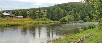
MANTUROVO, a city in Russia, in the east. parts of the Kostroma region, the center of the Manturovo district. Us. 17.8 thousand people (2010). Located on the right bank of the river. Unzha. Railway station.
It was first mentioned in 1617 as a village in the Watch Book of the city of Unzha. In 1620–54, M., as part of the Verkhovskaya volost, belonged to I. N. Romanov (uncle of Tsar Mikhail Fedorovich). After the peasant reform of 1861, the rapid development of entrepreneurship and trade began in Moscow; Since 1870, two fairs have been held here annually. In 1872, a pier was built near the village (near the village of Mokrovskoye), and from the 2nd half of the 1870s. The Unzhensky shipping company, specializing in the transportation of wood, was active. In 1906, traffic was opened along the railway that ran near the village. line Vologda - Vyatka (built Manturovo station), which contributed to the construction of sawmills in Moscow and the surrounding area: in the village. Efimovo - plant Moscow. merchant N.M. Kleev (1912), Belgian plant. firms "Dandre and Carbo", near M. - plant of the book. P. D. Dolgorukova (both in 1912–1913), near the village. Berezhki - plant gr. E.I. Krasinsky (1913). Around these enterprises, workers’ settlements developed, connected by a network of streets (the villages of Mokrovskoye and Gradulevo, and the station of Manturovo were also included in this structure); basic adm. and societies. institutions were concentrated in M. In the 2nd half. 1920s ex. plant book Dolgorukov was converted into a large plywood mill (production of plywood began in 1915; now the city-forming enterprise of M.), around which at the turn of the 1920s and 30s. the village began to take shape. Yurovsky (working village since 1935). M. is the regional center of Kostroma province. (1928–29), Nizhny Novgorod (from 1932 Gorky) region (1929–36), Gorky (1936–44) and Kostroma (from 1944) regions. Since 1929 it has been a workers' settlement. The city of M. was formed in 1958 with the merger of the working-class settlements of Manturovo and Yurovsky. In 1962, Gradulevo became part of the city, and in 1966, the villages of Rechkovo, Veshnyakovo and Zharikhino.
Manturovo. Bank building. 1990s Photo by P. S. Pavlinov
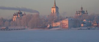
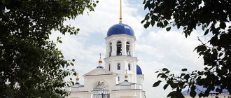
Archit. the dominant feature of the city is c. St. Nicholas in the former With. Mokrovskoe (1836; the refectory, bell tower and the completion of the temple were restored in 2000–10, architect L. S. Vasiliev), a temple covered with 5 lightweight domes with late Baroque decor. Among other architects. monuments: 2-storey wooden. merchant houses (D.V. and V.D. Krutikov, house with a shop of A.F. Bechin), a stone house with a shop on the 1st floor of the merchant V.Ya. Popov (all - late 19th - early 20th centuries. ), wood railway buildings station (including water tower, ca. 1905), former school. village Berezhki (1915–16), 2-story apartment buildings in the village. Yurovsky (1934–35 and mid-1950s), a lumber mill club in the neoclassical style (1954–57). In the 1990s. built: hotel, local history buildings. museum, bank with Art Nouveau elements.
The leading enterprise is a plywood mill (since 2007, part of the Sveza company). Tractor repair plant (mainly repair of logging equipment). Production of lumber, honey products. destination (bandages, cotton wool, etc.). Cheese factory, mineral bottling enterprises. water (Kologriv-M, etc.).
Near M., on the right bank of the river. Unzha, the following churches have been preserved: St. George's (1813; with an 8-sided main volume in plan and baroque decorative motifs) in the former. village Georgievsk (near the village of Shulevo), 2-storey Voskresenskaya in the style of classicism in the village. Ugory (1817), Resurrection in the Russian-Byzantine style in the village. Karkovo (1861) and in the village. Gusevo (1857–68); park of the estate of D. A. and M. P. Apukhtin “Otrada” in the village. Davydovo (2nd quarter of the 19th century).
Map
| Manturovo: maps |
Manturovo: photo from space (Google Maps) Manturovo: photo from space (Microsoft Virtual Earth)
| Manturovo. Nearest cities. Distances in km. on the map (in brackets along roads) + direction. Using the hyperlink in the distance , you can get the route (information courtesy of the AutoTransInfo website) | |||
| 1 | Vetluzhsky | 40 (69) | IN |
| 2 | Sharya | 42 (67) | IN |
| 3 | Georgievskoe | 47 (60) | WITH |
| 4 | Not me | 52 (53) | Z |
| 5 | Kologriv | 61 (81) | NW |
| 6 | Makariev | 75 (79) | SW |
| 7 | Vetluga | 80 (135) | SE |
| 8 | Parfenevo | 80 (362) | Z |
| 9 | Pyshchug | 82 (108) | NE |
| 10 | Ponazirevo | 90 (115) | IN |
| 11 | Antropovo | 103 (324) | Z |
| 12 | Varnavino (Nizhny Novgorod region) | 105 (225) | YU |
| 13 | Kadyi | 111 (118) | SW |
| 14 | Uren | 113 (180) | SE |
| 15 | Pavino | 117 (151) | NE |
a brief description of
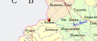
The city is located in the Volga region, on the right bank of the river. Unzha (tributary of the Volga), 261 km northeast of Kostroma. Railway station. Pier.
Territory (sq. km): 16
Information about the city of Manturovo on the Russian Wikipedia site
Historical sketch
It arose as a village about the railway. Manturovo station (opened in 1906), name - after the village of Manturovo (first mentioned in 1617). The oikonym is formed from the anthroponym: Mantur, Manturov - a number of persons of the 15th-16th centuries. in Novgorod, Pereyaslavl, Kashin.
Workers' village of Manturovo since July 18, 1927. Since 1958, a city.
The working settlement of Yurovsky (PGT since 1935, 2.5 thousand inhabitants, 1939) became part of the city (in 1958).
Municipal indicators
| Index | 2001 |
| Demography | |
| Number of births, per 1000 population | 8.4 |
| Number of deaths, per 1000 population | 20.7 |
| Natural increase (decrease), per 1000 population | -12.3 |
| Standard of living of the population and social sphere | |
| Average monthly nominal accrued wages, rub. | 1852 |
| Average housing area per inhabitant (at the end of the year), sq.m. | 22.8 |
| Number of preschool institutions, pcs. | 9 |
| Number of children in preschool institutions, thousand people | 0.8 |
| Number of daytime educational institutions (at the beginning of the school year), pcs. | 6 |
| Number of students in daytime educational institutions, thousand people | 2.8 |
| Number of doctors, people. | 57 |
| Number of nursing staff, people. | 243 |
| Number of hospital institutions, pcs. | 1 |
| Number of hospital beds, thousand units | 0.3 |
| Number of medical outpatient clinics, pcs. | 1 |
| Capacity of medical outpatient clinics, visits per shift, thousand units. | 0.5 |
| Number of registered crimes, pcs. | 643 |
| Persons who committed crimes were identified, persons. | 431 |
| Economy, industry | |
| Number of enterprises and organizations (at the end of the year), pcs. | 271 |
| Construction | |
| Volume of work performed by type of activity “Construction” (until 2004 - volume of work performed under construction contracts), million rubles. | 38.1 |
| Commissioning of residential buildings, thousand sq.m. of total area | 1.1 |
| Commissioning of residential buildings, apartments | 13 |
| Commissioning of preschool institutions, places | 0 |
| Commissioning of educational institutions, places | 0 |
| Commissioning of hospital facilities, beds | 0 |
| Commissioning of outpatient clinics, visits per shift | 0 |
| Transport | |
| Number of bus routes (in intracity traffic), pcs. | 3 |
| Number of passengers transported by buses per year (in intracity traffic), million people. | 1.9 |
| Connection | |
| Number of residential telephone sets of the city public telephone network, thousand units. | 3.4 |
| Trade and services to the population | |
| Retail trade turnover (in actual prices), million rubles. | 207.2 |
| Retail trade turnover (in actual prices), per capita, rub. | 9914 |
| Public catering turnover (in actual prices), million rubles. | 5.4 |
| Volume of paid services to the population (in actual prices), million rubles. | 28 |
| Volume of paid services to the population (in actual prices), per capita, rub. | 1338 |
| Volume of household services to the population (in actual prices), million rubles. | 2.1 |
| Volume of household services to the population (in actual prices), per capita, rub. | 100.7 |
| Investments | |
| Investments in fixed assets (in actual prices), million rubles. | 32 |
| Share of investments in fixed assets financed from budgetary funds in the total volume of investments, % | 8.4 |
Data sources:
- Regions of Russia. Main characteristics of the constituent entities of the Russian Federation: statistical collection. Goskomstat of Russia. - M:, 2003.
Economy
JSC - "Plywood Mill", "Manturovoles", medical preparations plant "Ingakamf". Flax plant, food industry enterprises.
In the Manturovo region flax, potatoes, and grain crops are grown. Mainly cattle are raised.
Oil shale deposits.
Main enterprises
FORESTRY, WOOD PROCESSING AND PULP AND PAPER INDUSTRY
OJSC Timber Industry Holding Company
157400, Kostroma region, Manturovo, st.
V. Naberezhnaya, 28 Offers:
Coniferous and hardwood lumber, garden and country furniture, parquet, souvenirs
WOOD PROCESSING INDUSTRY
OJSC "Manturovo Plywood Mill"
157400, Kostroma region, Manturovo, st.
Matrosova, 2b Offers:
plywood, upholstered furniture
Museums, galleries, exhibition halls
Manturovo City Museum of Local Lore 157400, Kostroma region, Manturovo,
| Population by year (thousands of inhabitants) | |||||||
| 1931 | 3.3 | 1996 | 21.9 | 2008 | 18.3 | 2017 | 15.6 |
| 1939 | 5.9 | 1998 | 21.4 | 2010 | 17.8 | 2018 | 15.5 |
| 1959 | 16.3 | 2000 | 21.2 | 2011 | 17.5 | 2019 | 15.2 |
| 1967 | 19 | 2001 | 21.1 | 2012 | 17.1 | 2020 | 15.0 |
| 1970 | 21.5 | 2003 | 19.5 | 2013 | 16.7 | 2021 | 14.7 |
| 1979 | 22.6 | 2005 | 18.9 | 2014 | 16.4 | ||
| 1989 | 22.5 | 2006 | 18.6 | 2015 | 16.1 | ||
| 1992 | 22.4 | 2007 | 18.3 | 2016 | 15.8 | ||
City of Manturovo
The village of Manturovo 1933
City of Manturovo. The city is named after the village of Manturovo, located near the Unzha River. The first mention of the village is found in the watch book of the city of Unzha in 1617. Boyar Yu.G. Lovchikov and clerk Marte-myanov in 1617, by order of the tsar, carried out an additional census (watch) of the Unzha siege, which then included Manturovo. This census was caused by the fact that the Galich district suffered greatly from the Polish interventionists, and the government needed to know the damage caused.
The sentinel book records: “The Verkhovskaya volost, and in it the village of Manturovo and in it the peasants’ courtyard of Ivashka Popov, the courtyard of Gavrilka Ivanov, the courtyard of Deniska Artemiev, and seven hectares of arable land (3.5 hectares - D.B.) and three heaps of hay.”
The Nikolsky churchyard, which stood next to the village of Manturovo, is described in more detail, on the site of which the village of Mokrovskoye (Nikola on Mokrom) later arose, which also later became part of the city: “The graveyard is in the Verkhovskaya volost and on the graveyard there is a temple in the name of the Wonderworker Nicholas and another warm temple in the name of Elijah the Prophet is made of wooden dumplings, and in the churches there are images and candles and books and vestments and bells and all the buildings of the world, and in the graveyard there is a mallow yard and a sexton’s yard, and in it the poor live and are fed from the Church of God.”
The book also rewrites the villages neighboring the churchyard: Gradylevo, in which there were 4 courtyards, Skorodumovo, where the yard of the priest of the St. Nicholas Church Posnik Ivanov stood, the village of Rychkovo, in which there were 2 courtyards, the village of Efimovo - 2 courtyards. Some of these villages were later lost or became part of the city of Manturova.
Steamship of the Unzhenskaya Flotilla "Manturovo"
A wide strip along the Unzha River from the city of Kologriv to the city of Unzhi stretched the Verkhovskaya volost, the lands of which at the end of the 16th century belonged to the brother of Anastasia Romanovna, the first wife of Ivan the Terrible.
When in Russia the struggle of the boyar parties of the Romanovs with the Godunovs ended in the victory of the Godunovs and B.F. Godunov came to power, the Romanovs and their relatives were imprisoned in monasteries and their estates were taken away from them. With the election of Mikhail Fedorovich Romanov to the throne, the lands were returned to the Romanovs and the Verkhovskaya volost was given to the Tsar's uncle Ivan Nikitich Romanov. In the census book of 1646 it is written: “The sovereign granted the boyar Ivan Nikitich Romanov the Verkhovskaya volost to the patrimony, and in the patrimony the village of Nikolskoye, and Gradylevo also in it the Church of the Wonderworker Nicholas and in the chapel of the Prophet Elijah, and near the church in the yard of the priest Posnik and the cell Mallow and in the village there is a yard of clerks.”
At that time, there were already 11 peasant households in Manturovo, in which the Opolevs, Gavrilovs, Popovs, Ponomarevs, Topolevs, Kozovlevs and others lived. From I.N. Romanov, Manturovo and the entire Romanov estate passed to his son Nikita Ivanovich, and after his death it was transferred to the Palace Department and the villages in it were distributed to service people as a salary for their service. In 1659, land surveyors Koptev and Kushnikov came to Verkhovskaya volost to distribute villages and demarcate them.
In the book “Distribution of Land” it is written: “According to the sovereign and the tsar and the Grand Duke Alexei Mikhailovich, I came to the Galich district in the Verkhovskaya palace volost, they painted the villages of the village of Nikolskoye and Gradylevo, and in it the church of the Wonderworker Nicholas and in the same village the courtyard of the sovereigns who lived clerks and in the yard there is a mansion - a janitor with a room and above the cage opposite the hall there is a canopy between them and a back room and two huts for people, a bathhouse and two cellars and above the cellars there are three granaries, a cookhouse and two cattle yards and now, by decree of the great sovereign, that yard is denied to the landowner Prince Osip Nikiforovich - son of Vyazemsky." At the same time, the village of Manturovo was given to princes P.Yu. Ukhtomsky and M.N. Vyazemsky, the village of Veshnyakovo to M.N. Vyazemsky and boyar A.A. Zyuzin, and the village of Rychkovo to Prince P.Yu. Ukhtomsky.
St. Nicholas Church in Manturovo
The impetus for the development of Manturov was the railway laid through it and the sawmills and plywood factories built here.
The sawmill of Tsodikov and Khitrovin was built in 1908, employing 30 workers.
The Berezhkovsky sawmill (Dandre and Korba) was built in 1911, the plywood sawmill of Prince Dolgorukov in 1912, where 100 people worked. In addition, the Krutikova steam flour mill operated near the village of Manturovo. Russia, Kostroma region, Manturovo on the map