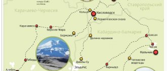
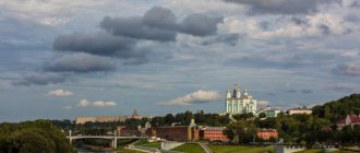
Samarskaya Luka National Park
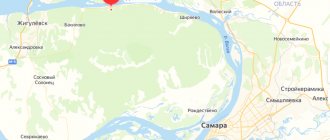
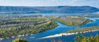
“Samarskaya Luka” is a peninsula formed by a bend in the Volga River, the flow of which first goes east, then changes direction to the southwest. The territory of the peninsula is surrounded by the waters of the Usinsk Bay and the Saratov Reservoir. The coordinates of the peninsula in the Samara region are 53°18′27″ N. latitude, 49°49′49″ e. d.
The peninsula is a conservation zone: the southern part belongs to the national park of the same name, the northern part to the Zhigulevsky Nature Reserve. Together they form a biosphere reserve, which is under the patronage of the international organization UNESCO.
The administration of the park is located in the city of Zhigulevsk, from where the distance to Samara is 100 km, to Togliatti 15 km, to Syzran 80 km.
The peninsula is connected to the Samara region by the M-5 highway; many highways are laid across the huge park area, leading to almost all attractions and beautiful places. On the coast of the peninsula, 10 marinas accept passenger and excursion ships, boats from Samara and Tolyatti.
You can travel on public roads without tolls or permits, but if travelers go on tourist routes, visit historical and cultural sites in populated areas, or intend to stay in recreational areas, they will need to purchase a permit for the duration of their stay.
You can buy a ticket on the official website, as well as directly in the park - in information centers and forestries:
- Samara, st. Kuibysheva, 127, of. 15;
- With. Zhiguli, st. Central, 6a;
- With. Bakhilovo, st. Polevaya, 3a;
- With. Sosnovy Solonets, Lesnaya, 23;
- With. Rozhdestveno, Sadovaya 32a;
- With. Shiryaevo, st. Zavodskaya, 4;
- With. Bolshaya Ryazan, Lesnaya, 13.
The administration of the national park is located in Zhigulevsk (Tkacheva St., 10a). The park is open from 9 a.m. to 10 p.m., forestry departments and checkpoints are open until 5-6 p.m.
The cost of a voucher for one tourist for 1 day is 50 rubles, a cyclist for 3 days with overnight stay pays 100 rubles. The national park is a popular vacation spot with many beautiful locations, so many vacationers purchase a weekend pass for 350 rubles.
A subscription for a monthly visit costs 1,000 rubles, for six months - 3,000 rubles. Travel by car is paid separately and costs 50 rubles. per car per day. To park a car in a comfortable parking lot, tourists pay a fee of 50 rubles.
Setting up a tent for 3 days in a recreational area costs 100 rubles, rest in equipped tourist houses costs 400-1000 rubles/day. A two-hour excursion for a group of up to 25 people will cost 2,000 rubles. The park's website contains a detailed price list for services.
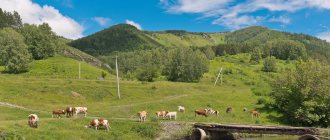
The territory of Samara Luka is formed by the Volga Upland and the Low Trans-Volga region, therefore the plains that dominate the relief in the south turn into forest-steppes. The northern part of the peninsula is covered by the Zhiguli Mountains, which are of tectonic origin. The highest point in the park is Mount Bezymyannaya, its height is almost 400 m.
Samara Luka is one of the most beautiful places in the Samara region
On 127 thousand hectares of park territory there are pine forests and deciduous forests, swamps and steppes. Of the 1,500 plant species that grow in this area, almost 20 are listed in the Red Book. Over 300 species of animals live permanently in the park.
Beautiful places in the Samara region attract tourists. The park has excursion routes to picturesque mountain peaks, caves, mounds, adits, and springs.
There are various routes throughout the park:
- bicycle;
- automobile;
- ski;
- snowmobiles;
- horse-drawn
For tourists to relax when visiting natural and historical sites, recreational locations have been arranged on the territory, they have places for lighting fires and setting up tents, and parking. In some areas, tourist houses welcome guests, there are souvenir shops, toilets, and cafes.
Recreation of Samara Luka is presented in the table:
| Site name | Coordinates | Types of recreation |
| Molodetsky Kurgan | 53°24'21″ n. latitude, 49°18'47″ e. d. | Suitable for picnics and beach holidays. |
| Shiryaevsky | 53°24'55″ N, 50°1'1″ E d. | Around the village Shiryaevo. Hiking trails begin at the town of Camel, the town of Popov, to the Stone Bowl and the Wine Spring spring. In winter, ski slopes are laid. |
| Mount Camel | 53°24'31.51″ n. latitude, 50°4'18.58″e. d. | Places for fires and tents. |
| Southern Zhiguli | 53°12'58″ n. latitude, 49°20'32″ e. d. | Fishing, picnic, horse riding and cycling. |
| Mordovinskaya floodplain | 53°10'20.24″ n. latitude, 49°26'27.15″ e. d. | Picnics, tent sites. |
| Witch Lake | 53°23'47″ n. latitude, 49°38'24″ e. d. | Around the village Bakhilovo. Picnic area, excursion trail. |
| Usinsk glades | 53.266350, 49.208367. | Fishing, horseback riding, picnics, beach. |
| Rozhdestveno | 53°14′14″ n. latitude, 50°03′34″ e. d. | Around the village Rozhdestveno. There is a tourist shelter “Shelekhmet”, fishing, horseback riding, water and hiking. |
| Zhigulevsky | 53.406381,49.483894. | In the city of Zhigulevsk (ecological center of Samarskaya Luka), a fox museum and educational center have been opened, there is an ecological trail, and an arboretum. |
| Ash Coast | 53.439958, 49.727235 | Around the village Ash. Places for picnics, fishing, camping. |
| Stone Lake | 53.349185, 50.129287 | Near. Podgory, on the shore there are places for picnics. |
Every year the national park receives over 1.2 million tourists.
Parks, entertainment and more
Museum "Motorworld of Vyacheslav Sheyanov"
Address: Volzhsky district, Petra Dubrava village, st. Klimova, 2B Telephone: Website: https://motos-of-war.ru/ Opening hours: 09:00 – 19:00 Mon-Sun Cost: 500 rubles, 300 rubles - preferential How to get there: by public transport - from Samara by buses No. 123 and No. 480 to the Petra Dubrava stop by car - exit onto Moskovskoye Shosse, turn onto Rakitovskoye Shosse, pass Zubchaninovka, exit onto highway 36K-851, turn off in front of the village of Stroykeramika and get to Petra Dubrava
The museum complex has collected a unique collection of the Golden Age of motorcycle construction, which occurred in the 1930–1940s.
There are 1,800 types of motorcycles from 14 countries, including: the best models of BMW and Harley Davidson, the first mass-produced Soviet motorcycle L-300 and tricycles - three-wheeled, tracked combat vehicles.
At Sheyanov’s Motorcycle World, motorcycles are restored so that they are as good as new.
Here you can not only learn more about motorcycles, but also ride them.
Garibaldi Castle
Address: Khryashchevka village, Rechnoy lane, 8 Phone: Website: https://garibaldicastle.com Opening hours: 07:00 - 21:00 Mon-Sun Cost: free How to get there: by public transport - from Tolyatti - minibus No. 320 from the Park House shopping center stop to the Khrushchevka village stop
Dominating the otherwise ordinary village is a neo-Gothic style castle that incorporates architecture from the Middle Ages, Renaissance and Victorian eras. It began to be built in 2006.
The interior of the castle is still being restored, so you can only get inside by appointment for a photo shoot.
Grushinsky Festival
Coordinates: 53.472444, 49.908555 Phone: 8 (846)-332-66-90 Website: https://grushinka.ru/ Cost: free How to get there: by public train to the Valery Grushin platform by car - https://grushinka .ru/2015/06/opisanie-proezda-do-grushinskogo-festivalya Distance from Samara - 50 km
A well-known festival of art songs, which has been held since 1968 - a year after the death of Valery Grushin himself.
He was a student at the Kuibyshev Aviation Institute, composed songs and played the guitar. Grushin died saving drowning people.
Many performers perform at the festival every year, including: Oleg Mityaev, Galina Khomchik, Vadim and Valery Mishchuki, Konstantin Tarasov. The chairman of the jury is Alexander Gorodnitsky.
Center for Historical Modeling "Ancient World"
Coordinates: 52.898153, 49.987975 Phone: Website: www.drevnymir.ru Opening hours: 10:00 - 17:00 Sat-Sun, Mon-Fri - days off How to get there: by public - by bus No. 631 "Samara-Pestravka" to village of Kamenny Brod by car - https://drevnymir.ru/events/priglashaem-posetiteley-v-drevniy-mir/ Distance from Samara - 47 km
- both a museum and a tourist site. Here you can immerse yourself in the old days:
- shoot a bow;
- ride horses;
- visit a real forge and pottery;
- see reconstruction of the Bronze and Stone Ages.
There are also master classes in pottery, making glass beads, cube printing, and quests in which “tribes” compete with each other.
Village Shiryaevo
Beautiful places for many vacationers and travelers are associated with the small village of Shiryaevo, located on the border of the Samarskaya Luka park area and the reserve. The village is located in the valley of the Zhiguli Mountains, coordinates 53°25′03″ N. latitude, 50°01′06″ e. d.
You can get to the village, located on the right Volga bank of the Samara region, by car along the M-5 highway, following the signs and driving 46 km. Travel by bus from Zhigulevsk (route No. 9) or by boat from Samara.
There is no charge for visiting Shiryaevo, but there is a fee for sightseeing, visiting museums and walking along the trails of the Samarskaya Luka National Park and Nature Reserve. The information center where tickets are sold is located on the street. Zavodskaya, 4.
There is a museum complex in the village; it consists of 3 museums that operate according to a single schedule: every day from 10 a.m. to 4 p.m., closed on Tuesdays.
The complex is located on the street. Sovetskaya, 14, it includes the following museums:
- The house where the artist I. Repin lived in the summer of 1870, who painted barge haulers and the Volga. The exhibition presents sketches and sketches.
- In the brick house of local businessman I. Vdovin, an exhibition dedicated to the life of Volga residents in the pre-revolutionary period is presented.
- In the house where the poet A. Shiryaev lived, his personal belongings are displayed and the furnishings are presented.
Repin House Museum
To view the exhibitions of the entire complex costs 120 rubles. full ticket, pensioners and children 60 rubles. A unique museum dedicated to bats also welcomes visitors. Chiropterans live in abandoned adits, where up to 30 thousand individuals gather for the winter.
The museum can only be visited with a guide (Lermontov St.). In the village, the building of a factory that produced lime from limestones mined nearby and the manager’s house (Zavodskaya St., 5) have been preserved; you can see it for free.
Near the village, on the slope of Mount Popov, there is an observation deck, which offers a picturesque view of the Zhigulevsky Gate - the narrowest point of the Volga bend. At the site there is a monument to miners and a memorial sign in honor of the state of Volga Bulgaria. The road from the village to Mount Popov takes 10 minutes, the ticket costs 50 rubles.
Zhigulevskie Gate
Shiryaevo is the starting point for many walking routes in the national park: from the village they go to the Monastyrskaya and Camel mountains, to the adits, the holy spring “Stone Bowl” and to the Shiryaevsky ravine.
Holy places of the Samara region
For peace of mind. Suitable for those who like to retire and think about more.
Stone bowl
Stone thicket on the map
Address: near the village of Shiryaevo
Prices: See tour prices here.
This is a rounded extension of the Shiryaevsky ravine, which is surrounded by 5 ravines and 5 mountains. Inside the ravine there are three sources of drinking water. One part of the attraction is located in a nature reserve, the other in a national park.
A walking tour to the Stone Bowl starts in the village of Shiryaevo. The water in the source is considered healing. A chapel and bathhouse were erected there in honor of St. Nicholas the Pleasant. A spring appeared in this area in a strange way. The area is made of limestone, which absorbs liquid. It is not clear how water could easily pass through the rocks.
You can get to the tract by car. You will have to leave the car 100 meters from the source. It is not recommended to visit the Stone Bowl in the rain.
Stone thicket
Holy Mother of God Kazan Monastery
Monastery in Vinnovka on the map
Address: Vinnovka village
Prices: from 150 rubles per person for a group excursion.
The monastery was founded in 2006. The complex includes residential buildings, churches, and a bell tower. On the territory of the monastery there is a museum of the history of the village of Vinnovka and a library. The monks strengthened the pier, and now it accepts four-deck ships.
Residents of the monastery breed young sterlet to release it into the Volga. Thus, they compensate for the harm caused by fishing activities.
You can get to Vinnovka by car or by ferry.
Monastery in Vinnovka
Mount Camel and adits
Around the village In Shiryaevo, adits from the 19th century have been preserved. Man-made caves were carved out during the extraction of limestone, which is necessary to obtain lime. The adits belonged to the breeder P. Ushakov.
The adits maintain +5 0C and high humidity all year round. Remains of mining equipment have been preserved in the stone labyrinths, but the adits are at risk of collapse. You can go into the depths of the man-made dungeon only with an organized excursion; tourists can only explore the part closest to the exit on their own.
The cost of visiting is 50 rubles, the same price includes a visit to the ecological trail to the Popov and Camel mountains. The ticket must be purchased at the information center.
3 km from the village. Shiryaevo is Mount Camel, its western slope received its own name - Monastic Mountain. The height of the massif, stretching along the Volga for 4 km, is 326 m. In the summer, climbers train on the steep slopes.
On Mount Camel you can see the remains of a quarry in which limestone was mined. The quarry was named Vanyushin in honor of the merchant who owned it. Tourists are attracted by the observation deck, which offers a panoramic view of the Volga and the Zhiguli Gate. The site is located on a rocky ledge located 120 m above the river.
Stone bowl and Nikolsky spring
From the village Shiryaevo begins a walking route to the Stone Bowl tract. There is a spring in the tract, the water of which is considered healing and holy. Near the spring there is a bathhouse and a chapel of St. Nicholas. Access is open from 8 a.m. to 8 p.m. (summer) and until 5 p.m. (winter), visiting is paid.
From the village of Shiryaevo, the Stone Bowl is located 9 km away; you can drive along a dirt road by car. Along the way, the Bear Grotto on the mountainside attracts attention, but you are not allowed to leave the trail.
Zhigulevsky Reserve
Beautiful places in the Samara region are mainly located on Samarskaya Luka. In the north of the peninsula, the Zhigulevsky Reserve is located; it occupies 23 thousand hectares of the Zhigulevsky Mountains and is part of the Middle Volga Reserve. The reserve's topography is rugged; the valleys between the canyon-like ravines are covered with herbs.
Almost the entire territory is covered by forests, where 882 species of plants are represented, some of them are endemic and relicts of different geological periods. The fauna of the Zhigulevsky Nature Reserve is also diverse: it is home to almost 40 species of mammals and more than 150 species of birds.
The administration of the reserve is located in the village. Bakhilova Polyana, st. Zhigulevskaya, 1. Coordinates 53°24′54″ N. latitude, 49°49′17″ e. d., travel along the M-5 highway towards the village. Bakhilovo. Unlike the Samarskaya Luka National Park, tourists can visit the reserve only along 2 routes.
As part of an excursion or on your own, you can go to Strelnaya Mountain and the Stone Bowl spring. Payment for the visit is made at the visitor center.
Since 2016, near the visitor center, an open-air cage complex has been built in which badgers are kept; these animals are a symbol of the Zhigulevsky Nature Reserve. The spacious enclosure is home to 3 badgers born in hunting grounds. You can watch the animals for free.
From 8 a.m. to 4 p.m. every day, 2 museums are open at the visitor center; admission to them is free.
The Museum of Nature presents several collections:
- geological, has 200 samples of rocks and minerals;
- fossils of the Mesozoic and Paleozoic era;
- bird's nests;
- insects;
- paintings and photographs.
Also hosting guests is a museum of scientific research named after Sprygin, the founder of the protected area. The museum is designed in the form of a researcher’s office and is equipped with instruments for conducting interactive and practical classes.
To organize a lesson at the museum, a preliminary application is required; the cost of a lesson for a group of up to 7 people is 500 rubles. on weekdays and 1000 rub. on the weekend.
Mount Strelnaya
Beautiful places in the Samara region can be seen from afar, and one of them is Mount Strelnaya, the highest peak of the Zhigulevsky massif (351 m). Strelnaya is the only accessible peak in the Zhigulevsky Nature Reserve.
Pedestrians and cyclists are not allowed on the mountain. There is a car route to the observation deck at the top: you need to go to the village. Zolnoye, purchase an entrance ticket at the checkpoint and drive another 6 km to the observation deck. Coordinates 53.432888, 49.763312.
The cost of a car ticket (up to 5 passengers) is 500 rubles, the checkpoint is open from 8 a.m. to 8 p.m. Visitors should stay at the top of the mountain for no more than 2.5 hours, because The number of parking spaces is limited.
At the top of Strelnaya there are observation platforms connected by a metal pedestrian bridge with fences. The length of the pedestrian part is 320 m. The platforms and bridges offer views of the Volga, islands, nature reserve and hydroelectric dam.
Strelnaya has historical significance: it is believed that it was on it that a detachment of Cossack freemen under the leadership of S. Razin was located. However, the conservation value of the territory in which relict rocky steppes grow is much more important. Therefore, getting out of cars on the way to the top is prohibited.
Monumental buildings of Samara and the region
Objects that shaped the appearance of the city and region. For lovers of beautiful photographs.
Zhigulevskaya HPP
Hydroelectric power station on the map
Address: Zhigulevsk, Moskovskoe highway, 2
Construction of the structure began in 1950. The hydroelectric station finally began operating in 1957. Many villages went under water due to the commissioning of the station. It consists of two platinums - drainage and earthen. Ships pass through locks - this is a structure that “transports” the ship to the desired water level (higher or lower). The Kuibyshev reservoir is considered one of the largest in Europe.
The hydroelectric power station not only generates energy for several cities and dozens of settlements, but also protects against floods and helps develop shipping in the country.
We recommend visiting the hydroelectric power station during the period of water release. This is April - May. Detailed information about reset times can be found on the Internet. The spectacle is similar to a sea storm: changes in water level, foam and wind attract hundreds of tourists.
Zhigulevskaya HPP
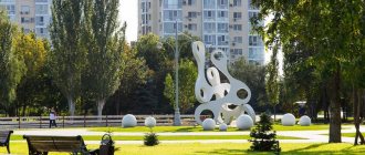
Samara embankment
Embankment on the map
Samara embankment is the heart of the city, a place for meetings and festivals. In warm seasons it attracts a huge number of residents and tourists, becoming a place of “Volga life”.
The territory is divided into 4 stages, which were built one after another. The length of the embankment is 4168 meters. Parallel to the walking area there is a beach part where tourists can sunbathe.
Construction of the embankment began in 1935. At the beginning of the 20th century, this territory was a kind of warehouse for unnecessary things and garbage. Since 2012, a gradual reconstruction of the embankment queues began. Now it is a modern place for walking and leisure.
Samara embankment
Blue Lake
The beautiful places of the Samara region are located at a sufficient distance from the regional capital. But tourists come 120 km from Samara, so that in the Sergievsky district near the village. Old Yakushkino see a natural monument - a karst lake.
Because of the color of the water, the lake was named Blue; another name, Dead, reflects the fact that the waters and the coastal strip around the reservoir are uninhabited. Only algae, bacteria and 4 types of worms can survive in water saturated with hydrogen sulfide.
The natural lake with a diameter of 42 m has a completely round shape, a maximum depth of 28 m. In the reservoir, which is fed by powerful underground springs all year round, the water temperature throughout the year is invariably +6-8 °C.
The coordinates of the natural object are 53°54′44″ N. latitude, 51°29′15″ e. d. By car, drive along the M-5 highway in a northeast direction until you turn to Staroye Yakushkino.
Tsarev Kurgan
30 km from Samara near the village of Volzhsky there is a hill of an unusual dome shape. A hill resembling a banquet table rises above the confluence of the Sok River and the Volga. This natural monument of regional significance is one of the most picturesque places in the region. You can get to the mound along the Krasnoglinskoe highway, coordinates 53.422585°, 50.123097°.
From the top of the hill a panorama of the Volga and Soka spouts and the Zhiguli Mountains opens up. The mound was first mentioned in chronicles in 1636, but archaeologists discovered nearby traces of ancient people’s habitation.
The mound is covered in legends. It is believed that the hill arose on the orders of Tamerlane, who ordered each warrior to place a stone on the river bank. Another legend claims that Ivan the Terrible, while besieging Kazan, ordered the mound to be dismantled. It is known for sure that Peter I climbed the hill during the Azov campaign.
Popular rumor attributes visits to a noticeable hill above the Volga to Catherine II, Alexander I, Lenin; many residents are still convinced that the ataman of the Cossack freemen Stepan Razin hid countless treasures in these places.
At the end of the 19th century. They began to destroy the mound, extracting stone from it, first for the construction of a bridge, and then for the Kuibyshev hydroelectric station. Back in 1900, the height of the hill was more than 100 m, but now the mound has been halved, and the abandoned quarries are overgrown with forests. At the top of the Tsarev Kurgan there is a penitential cross, at the foot there is the Church of the Nativity of Christ and a holy spring.
Natural monuments of the Samara region
For the soul and active recreation alone or with a group of friends.
Mount Strelnaya
Mount Strelnaya on the map
Address: Zolnoye village, Samara region.
Operating hours: Starts working in the second half of spring. You can check the price and opening date of the route on the website
To ensure there are fewer tourists on the mountain, go to it before 11 am. Don't forget to leave time to purchase your ticket. You also need to stand in line of cars and minibuses.
Mount Strelnaya is the second highest in the Zhiguli Mountains. It rises 370.6 meters above sea level. The ridge first drops a little, and then sharply “takes off” and forms a viewing platform. To get to the top, you need to cross the “Devil's Bridge” - this is a narrow stone ridge.
On the mountain there is a rare phenomenon - “rocky steppes”. They make up 1.5% of the reserve's territory. Outside Samarskaya Luka, the steppes almost disappeared, as they were trampled and quarried.
The name most likely appeared in the 16th-17th centuries from the Old Russian “strelnya”, which meant watchtower.
Mount Strelnaya
Adits in Shiryaevo
Adits on the map
Located near the village of Shiryaevo. The adits were used for limestone mining but are now abandoned. You can enter the tunnels at any time of the year. Local guides talk about the history of the adits and the legends associated with them.
Don't forget to purchase national park passes before visiting the caves.
National Park “Samarskaya Luka”
Samarskaya Luka National Park on the map
Opening hours: Year-round. Tickets can be purchased at the ticket office.
Prices: from 50 rubles per person. It is better to look at the prices here.
The park was founded in 1984. The area it occupies is more than 130 hectares. The territory occupies several districts and is divided into 5 forest districts. The Volga is the main artery of the park. The river feeds the national park and is the crown jewel of the area. Samarskaya Luka contains natural attractions: mountains, tracts, caves. In Shiryaevo, visit the Repin Museum, and in Zolny, the Zhiguli Fairy Tale Museum.
Tsarev Kurgan
Tsarev Kurgan on the map
Address: Volzhsky, st. Stepana Razin, 30
Opening hours: All year round
The mound is located near the village of Volzhsky. The place was first mentioned back in 1636. Tsarev Kurgan was visited by Stepan Razin, Tamerlane and Peter the Great. Real stories and legends are intertwined here. They created a unique image of the territory. At the top of the mound there is a cross, and near the rise there is a church with a holy spring.
Tsarev Kurgan
Usinsk Kurgan
Usinsky Kurgan on the map
Address: outskirts of the village of Zhiguli
Opening hours: All year round
Prices: See tour prices here.
Mount Lepeshka (this is the second name of the mound) is located at the confluence of the Usa and Volga rivers. The most attractive view of the Usinsk mound from the water. From the Volga side, the mound looks like a layer cake, as layers of rocks are visible. Kurgan was a favorite place for robbers, since the Volga is clearly visible from here. Thus, it was possible to prepare in advance for an attack on ships.
Usinsk Kurgan
Mastryukovsky lakes
Mastryukovsky lakes on the map
This is a group of lakes that are located in the area, not far from the Mastryukovo station. Since the last century they have been a natural monument of regional significance. The purpose of creating the monument is to preserve the forest habitat of animals and plants that are listed in the Red Book. The lakes attract a large number of tourists every year.
Mastryukov Lakes
Zolnoe
Zolnoye on the map
The village is part of the Zhigulevsk urban district. Until 2010 it was a rural settlement. Zolnoe was formed in the mid-20th century, when oil was discovered in the Zhiguli Mountains. The village is located in a beautiful natural place, where ferries from Samara arrive. In the village there is a museum dedicated to the legends and fairy tales of the Zhiguli.
Zolnoe
Soksky quarry
Soksky quarry on the map
Limestone and stone were mined here. Because of the mining, a recognizable relief appeared here - huge steps in the middle of the mountain. There are also adits from which stone has been removed since the 50s of the 20th century. You can visit them, just be careful.
The quarry is famous for having more than 40 km of underground tunnels. Already in the second half of the 50s, stone began to be mined using open pit mining. This is how the quarry appeared. Tsarev Kurgan was destroyed in half. In the 1980s, work in the Soksky quarry ended as it was exhausted.
Now tourists come here to take unusual photos or climb into the caves.
Soksky quarry
Racheisky Bor
Racheisky Bor on the map
Bor was founded in 1983. Located near the village of Staraya Racheika. The natural monument can be visited, but with some restrictions. Most of the territory is occupied by pine forests. The relief changes smoothly, and rare species of fauna and flora live in the forest. Racheysky Bor is of scientific value to people.
Racheisky Bor
Cave of Stepan Razin
Razin's Cave on the map
Opening hours: 24 hours a day
Price: See the cost of the tour here.
The cave is located 2 kilometers from the village of Malaya Ryazan. This is the most remote attraction in the national park. The cave is small and consists of a hall 20 by 4 meters. It is possible to enter the cave only in a bent position. The depression was formed as a result of rocks being washed away by water.
The name of the cave was given by a real story or legend. It is believed that Stepan Razin, the leader of the 17th century uprising, used this depression to live or store jewelry.
Inspecting the cave takes tourists about 10 minutes. Nearby there are places to pitch tents and drinking springs for relaxation.
Razin's Cave
Basement terraces
220 km from Samara in the Shigonsky district on the border with the Ulyanovsk region there is a natural monument called the Podvalsky terraces. Terraced landslides on the chalk hills, located on the right bank of the Volga, create steps 100-155 m high above sea level.
The terraced slopes are covered with rocky steppes, in which Red Book plants grow. The location is inhabited by bobak marmots; they have created the largest colony in the Samara region in these places. From the top of the hilly ridge there is a panoramic view of the valley, meadows and river.
From Samara to Podvalskie terraces travel along the M-5 highway through Togliatti, in Pecherskie Vyselki turn right, then move to the village. Basement. Coordinates 53°42′02″ N. latitude, 48°49′42″ e. d. Visiting the natural site is free.
Churches, temples and cathedrals
Iversky Convent
Address: Samara, Volzhsky Ave., 1 Phone: Website: https://samara-iversk.cerkov.ru/ Opening hours: 07:30 - 20:00 Mon-Sun
The Iversky Convent was founded in 1850. It received its name because of the wishes of a merchant’s wife, who donated the family Iveron Icon of the Mother of God.
Under Soviet rule, most of the monastery was destroyed and its members were shot. In the Soviet Union, clubs were located here. But in the 90s, the monastery returned to the ownership of the Russian Orthodox Church.
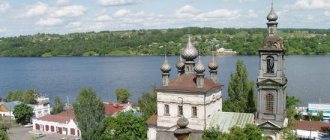
Holy Mother of God Kazan Monastery in the village of Vinnovka
Address: Vinnovka, st. Kazachkova, 3 Phone: 8-964-975-25-08 Website: https://sbkmenmon.cerkov.ru Opening hours: 07:00 - 19:00 Mon-Sun
The monastery was built by the famous Samara architect Yuri Kharitonov, who built the Church of the Great Martyr George the Victorious in the center of Samara.
The monastery has a 47-meter bell tower in the form of a lighthouse and an extensive library. On its territory, archaeologists have discovered several Neolithic sites.
Sterlet fry are bred here and released into the Volga to restore the population.
Church in honor of the Icon of the Mother of God of Kazan in the village of Vinnovka
Address: Vinnovka, st. Kazachkova, 3A Phone: 8-964-975-25-08 Website: https://sbkmenmon.cerkov.ru Opening hours: 07:00 - 19:00 Mon-Sun
The first church was built in 1770, but burned down in a fire in 1839. In 1851 it was rebuilt again, only this time from stone.
In the 1930s, the authorities closed the temple, threw the bells into the river, bent the cross, and destroyed some of the icons. Later the church was restored.
Church in honor of the Baptism of the Lord in the village of Kurumoch
Address: Kurumoch, Lenin Ave., 1A Telephone: Website: https://volz-kurumosh.cerkov.ru/ Opening hours: 08:00 - 18:00 Mon-Sun
One of the few surviving pre-revolutionary churches in the Samara region. It was built in the style of Russian-Byzantine architecture.
During the Soviet period it was used as a workshop and warehouse. The church was restored and re-consecrated in honor of the Epiphany.
Holy Trinity Church and holy spring in the village of Tashla
Address: Tashla, Central St., 35 Phone: 8 (84862) 45-112 Website: https://tash-svtroizy.cerkov.ru/ Opening hours: 09:00 - 19:00 Mon-Sun
In the Holy Trinity Church there is an icon of the Mother of God “Deliverer from Troubles.”
According to legend, thanks to her a holy spring arose. One woman dreamed of the Mother of God, who pointed out where the icon lay. As soon as it was taken out, a source formed in the same place.
Racheisky Bor
One of the most beautiful places in the Samara region is located near the village. Old Racheyka in the Syzran region. Coordinates 53°22′42″ N. latitude, 47°59′01″ e. d.
Racheisky Bor occupies 1336 hectares in the forest-steppe, but is a natural taiga in southeast Russia. This is a unique natural anomaly. Bor is a dense pine and spruce forest where cranberries and blueberries grow in the swamps.
The natural diversity of the forest is impressive: about 400 species of plants grow there, and almost 90 species of birds come to nest. This amazing natural monument was taken under protection in 1983.
In the future, it is planned to create a natural park of the same name, which, in addition to the taiga forest, will include Racheyskie rocks, Mokhovoe and Uzilovo swamps, and the Semiklyuchye forest ravine. Visiting is free and not prohibited, provided that vacationers do not light fires.
When going by car on a summer trip around the Samara region, picturesque landscapes can be found both close to cities and near villages and towns. The beautiful places of the Samara region became a source of inspiration for I. Aivazovsky, F. Vasiliev, I. Repin: their canvases depicted the endless expanses of water, plains and mountains of the Middle Volga region.
Restaurants and snack bars
- " At Wakano's." Branded restaurant of JSC “Zhigulevskoe Beer”. Address: Volzhsky Prospekt, 4.
- Bar "At the bottom". A remarkable establishment, located at the same address.
- Red Rak Shellhouse . Drinking beer without crayfish in Samara is bad manners. Check it out here. Local reds are very good. Address: Kuibysheva, 91.
- Restaurant "Old Pier". Where: embankment at the exit to Volzhsky Prospekt. Be sure to order the “Volga fish soup with pike perch”;
- Restaurant "Russian Hunting" . There is a live fireplace in the interior, and on the table there is a fish soup and a roast “Russian Hunt”: boar, elk and roe deer seasoned with vegetables and herbs on a sizzling frying pan. Where: near Kurumoch airport.
If you come to Samara with children, be sure to try the local Sampo ice cream. There are branded kiosks on the embankment, and it also happens in supermarkets.