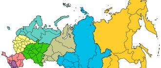
The Ivanovo region is located in the Central Federal District. More than 1 million people live on the territory of this subject of the Russian Federation. On the map of the Ivanovo region from a satellite you can see roads and railways, cities and small settlements. The main water bodies in the region are the Klyazma and Volga rivers. During navigation, river transport docks in the following cities:
- Kineshma;
- Yuryevets;
- Puchezh;
- Zavolzhsky.
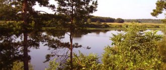
Using a map of the Ivanovo region with diagrams, you can find 1,700 rivers and 150 lakes. The largest water body in the region is the Gorky Reservoir.
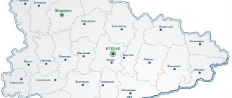
The Ivanovo region ranks second to last among all regions of the country in terms of territory - it is only about 24 thousand km2. Most of the people inhabiting it live in cities and only a little more than 20% live in rural areas. As the map of the Ivanovo region by district shows, the territory of the region is limited from different sides by 4 regions:
- Kostroma;
- Yaroslavskaya;
- Nizhny Novgorod;
- Vladimirskaya.
To get a complete picture of the location of cities, rivers, and transport routes in the region, you can move around the map with the mouse, zooming in or out and moving in the desired direction. A convenient online service can become an indispensable assistant for travelers, motorists, guests and residents of the region.
Districts of Ivanovo region on the map
You can view all the districts in detail on the map of the Ivanovo region. They are approximately the same in area, but differ in the number of people living. In total, the region is divided into 21 districts, the most densely populated of which are:
- Ivanovsky:
- Kineshemsky;
- Shuisky.
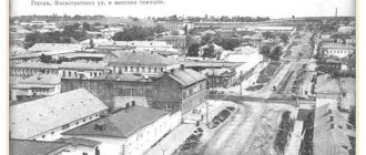
The fewest people live in the Savinsky district, which is located on the southern border of the region. And the Ivanovo district, with its administrative center - the city of Ivanovo, is traditionally considered the weaving center of the country.
To move around the region from one area to another, the population uses road, rail and water transport. A detailed road map of the Ivanovo region will help you find the main transport arteries of the region, routes:
- M-7 "Volga";
- R-600;
- R-79.
In total, there are about 5,000 km of asphalt roads in the region. A few years ago, a large road bridge was built across the Gorky Reservoir in the Kineshma region.
On the map of the Ivanovo region with settlements you can find railway stations and train stations. The largest railway depot in the region is located in Ivanovo.
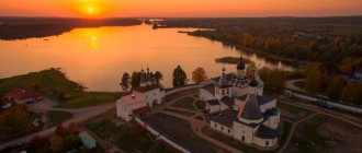
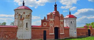
From a tourist point of view, the most interesting are the Shuisky and Yuryevetsky districts. Around the city of Shuya there are several ancient, beautiful monasteries that attract pilgrims. The main historical and architectural monuments are located in the Yuryevets district.
ADMINISTRATIVE-TERRITORIAL DIVISION OF THE IVANOVSK REGION / POST SUBMIT AN AD
HIPERINFO NOTICE BOARD | ADD AN ADVERTISING IVANOVSK REGION
IVANOVSKAYA REGION Ivanovo region is an administrative-territorial unit in the European part of Russia, a subject of the Russian Federation, part of the Central Federal District. Awarded the Order of Lenin (1967). Area - 23,900 km². Population - 1066.5 thousand people (as of January 2010). The regional center is the city of Ivanovo, the distance from Ivanovo to Moscow is 275 km. View larger map Geography The region is located in the center of the European part of Russia. Most of it lies between the Volga and Klyazma rivers. Area - 21,437 km² (one of the smallest regions of Russia, larger only than Kaliningrad). It borders on the Vladimir, Nizhny Novgorod, Kostroma and Yaroslavl regions. The length of the territory from north to south is 158 km, from west to east – 230 km. Relief, geology and minerals Forest edge. Ivanovo region. The surface of the region is a low-lying, slightly hilly plain, elevated above sea level by 130-150 meters. Small elevations are found in the southwest where the remnants of the Moscow Upland manifest themselves, and in the north there is a section of the Galich Upland, here the cities of Furmanov, Privolzhsk and Plyos are located in high areas. The highest point of the region - 196 meters above sea level - is located on a ridge in the Zavolzhsky region. The central and south-eastern parts of the region are low-lying; on the banks of the Klyazma there is a minimum elevation of 75 meters. On the flat sandy plain here you can see many small lakes and peat bogs. A whole cluster of karst sinkholes is found in the Savinsky region. There are also moraine remains in the region; the ridge in the vicinity of Shuya, with the Aspen Mountain forest located on it, is widely known. Minerals Two deposits of glass sands of federal significance have been identified. The Palekh deposit (Palekh district) has been explored with industrial reserves of 3,400 thousand tons. The Kudrevatinskoye (Lezhnevsky district) deposit has reserves of 1216 thousand tons of sand. In the Yuryevets district, the Darkovskoye phosphorite deposit of federal significance was studied on an area of 1229 hectares with reserves of 4525 thousand tons. There are reserves of molding clays in the amount of 11,919 thousand tons, peat with balance reserves of 110 million tons, sapropel with total reserves of up to 72 million m³, fresh groundwater with operational resources of 2.7 million m³/day, mineral, medicinal table and medicinal The groundwater. There are reserves of building materials: fusible clays (37.9 million tons), expanded clay raw materials (14.2 million tons), construction and silicate sands (73.6 million tons) and sand and gravel material (73 million tons). Climate The climate of the region is moderate continental. It is characterized by relatively warm summers and moderately frosty winters with stable snow cover. The coldest month of the year is traditionally January with an average monthly temperature of −11.5 °C ÷ −12 °C, and the warmest month of summer is July with an average monthly temperature of +17.5 °C ÷ +18 °C. Precipitation is about 550-600 mm per year. The predominant wind direction is southwest. Freeze-up on the rivers begins in late November, on the Gorky Reservoir in mid-December. The maximum height of snow cover during the winter occurs in the first ten days of February and is about 30-50 cm. The soil freezes to a depth of 25 to 45 cm. Fluctuations in the water regime of rivers do not have a noticeable effect on economic activity. Hydrography The Teza River near the village of Sergeevo near Shuya. There are about 1,700 rivers and streams and more than 150 lakes in the region. The largest river is the Volga, with the Gorky Reservoir located on it and the tributaries Shacha, Mera, Elnat, Kineshemka. The main part of the flow belongs to the Klyazma basin, among them: the Nerl (with the Ukhtoma tributary), the Uvod (with the Ukhtokhma and Vyazma tributaries), the Teza (with the Parsha and Lyulekh tributaries) and the Lukh (with the Landeh tributary). The main part of the lakes is located in the center and south of the region: Podozerskoye, Yuritsinskoye, Gusevskoye, Serkovskoye in the Komsomolsky district, oxbow lakes Orekhovoye, Dolgoye and Sorokino in the Klyazminsky reserve, lakes Shadrino, Lamskoye, Svyatoye, Ponyhar, Zaborye, and the deepest in the region Kleshchinskoye (35 meters) are located in the Yuzhsky district. A significant part of the small lakes are swamped; many lakes were formed on depleted peatlands. The largest and most easily accessible lake Rubskoye (mirror area - 2.97 km²) is located in the Teikovsky district on the A113 Kostroma-Vladimir road. In addition to Gorkovsky, there are several reservoirs in the region, among them Uvodskoye (supplemented by the Volga-Uvod canal) and Morkushskoye. The area of land under surface water bodies, including swamps, amounted to 115.7 thousand hectares (5.4%). Of these, 65.0 thousand hectares are under rivers, streams, lakes, reservoirs, ponds, and 50.7 thousand hectares are under swamps. Soil White willow during flowering. Savinsky district. The predominant soil type is soddy-podzolic with a small amount of humus, sandy loam in the central and southern parts, loamy in the northeastern parts of the region. In addition, drained peat soils are common, the lands in the Balakhninskaya lowland are occupied by swamps, and gray forest soils are found in the Ilyinsky and Gavrilovo-Posad regions. Vegetation The region is located at the junction of two zones: European taiga and mixed forests. In total, forests occupy 48% of the region's territory, and meadows about 10%. Especially the forested Zavolzhsky, Yuzhsky and Teykovsky districts. In 1972, the flora of the region included almost a thousand species of wild and cultivated plants. In 2005, the forests of the Ivanovo region occupied 1037.5 thousand hectares, or 48% of the total area. The share of coniferous forests was 46% of the forested area, young forests 28%, middle-aged 37%, ripening forests - 20%, mature and overmature forests - 15%. The estimated cutting area for final felling was 1,509.4 thousand m³. In 2004, about 750 thousand m³ of wood was harvested of all types. Ecology Forest fire near the city of Yuzha in the Ivanovo region The ecological state in the region is relatively favorable. Foci of pollution are the industrialized cities of Ivanovo, Shuya and Kineshma. Among the environmental objects, the federal Klyazminsky reserve on the territory of the Savinsky and Yuzhsky districts, with an area of 21,000 hectares, stands out, protecting the natural complex as a whole, the animal species living in it and in particular the Muskrat. From May 6 to May 16, 2010, a huge forest fire burned in the Ivanovo region, aggravated by the May heat, impenetrable forest, peat bogs and the negligence of officials. About 10 thousand hectares of forest burned.
Ivanovo city Vichuga city Kineshma city Kokhma city Teykovo city Shuya city Municipal districts Verkhne-Landekhovo district Gavrilovo-Posadsky district Zavolzhsky district Ivanovo district Kineshma district Komsomolsky district Lezhnevsky district Lukhsky district Palekhsky district Pestyakovsky district Privolzhsky district Puchezhsky district Rodnikovsky district Savinsky district Teykovsky district Furmanovsky district Shuisky district Yuzhsky district Yuryevets district
ADMINISTRATIVE-TERRITORIAL DIVISION OF THE IVANOVSK REGION The Ivanovo region includes: 21 municipal districts, 4 city districts, 6 cities of regional subordination, 11 cities of regional subordination, 31 workers' villages. The administrative center of the Ivanovo region is the city of Ivanovo. In 2005, during the municipal reform in the Ivanovo region, the composition of the districts was changed. Below is the modern administrative division of municipal districts. Administrative map of the Ivanovo region Urban districts City of Ivanovo Leninsky district Sovetsky district Oktyabrsky district Frunzensky district City of Vichuga City of Kineshma City of Kokhma City of Teykovo City of Shuya Municipal districts Verkhne-Landekhovo district Administrative center - town of Verkhniy Landekhovo OKATO code - 24 202 000 000 Municipal entities: Verkhnelandekhovo city settlement Kromskoye rural settlement Mytskoye rural settlement Simakovskoye rural settlement Vichuga district Administrative center - the city of Vichuga OKATO code - 24 201 000 000 Municipal entities: Kamenskoye urban settlement Novopiststsovskoye urban settlement Starovichugskoye urban settlement Gavrilkovskoye rural settlement Golchikhinskoye rural settlement Zarubinskoye rural settlement Zolot Ilovskoye rural settlement Marfinskoye rural settlement settlement Semenovskoye rural settlement Semigoryevskoye rural settlement Soshnikovskoye rural settlement Chertovischenskoye rural settlement Gavrilovo-Posadsky district Administrative center - the city of Gavrilov Posad OKATO code - 24 203 000 000 Municipalities: Gavrilovo-Posadskoye urban settlement Petrovskoye urban settlement Lobtsovskoye rural settlement Novosyolkovskoye rural Osanovetskoe rural settlement Shekshovskoye rural settlement Zavolzhsky district Administrative center - the city of Zavolzhsk OKATO code - 24 205 000 000 Municipal entities: Zavolzhskoye urban settlement Vozdvizhenskoye rural settlement Goltsovskoye rural settlement Dolmatovskoye rural settlement Esiplevskoye rural settlement Zhazhlevskoye rural settlement Zarechnoye rural settlement Kolshevskoye rural settlement Kornilov skoe rural settlement Novlyanskoe rural settlement Cheganovskoye rural settlement Ivanovo district Administrative center - the city of Ivanovo OKATO code - 24 207 000 000 Municipal entities: Balakhonkovskoye rural settlement Belyanitskoye rural settlement Bogdanikhskoye rural settlement Bogorodskoye rural settlement Kolyanovskoye rural settlement Kulikovskoye rural settlement Novotalitskoye rural settlement Ozernovskoye rural settlement Podvyaz Novskoye rural settlement Timoshikhskoye rural settlement Chernorechenskoye rural settlement Ilyinsky district Administrative center - the town of Ilyinskoye-Khovanskoye OKATO code - 24 209 000 000 Municipal entities: Ilyinskoye urban settlement Ankovskoye rural settlement Ivashevskoye rural settlement Isaevskoye rural settlement Shchennikovskoye rural settlement Kineshma district Administrative center - the city of Kineshma OKATO code - 24 211,000 000 Municipalities: Navolokskoye urban settlement Batmanovskoye rural settlement Gorkovskoye rural settlement Laskarikhinskoye rural settlement Lugovskoye rural settlement Reshemskoye rural settlement Shilekshinskoye rural settlement Komsomolsky district Administrative center - the city of Komsomolsk OKATO code - 24 213 000 000 Municipalities: Komsomolskoye urban settlement Markovskoye village settlement Novousadebskoe rural settlement Oktyabrskoye rural settlement Pistsovskoye rural settlement Podozerskoye rural settlement Lezhnevsky district Administrative center - township Lezhnevo OKATO code - 24 214 000 000 Municipal entities: Lezhnevskoye urban settlement Voskresensk rural settlement Lezhnevskoye rural settlement Novo-Gorkinskoye rural settlement Sabinovskoye rural settlement Khoznikovskoye s Elskoye settlement Cherntskoye rural settlement Shilykovskoye rural settlement Lukhsky district Administrative center - urban-type settlement Lukh OKATO code - 24 215 000 000 Municipal entities: Lukhskoye urban settlement Blagoveshchenskoye rural settlement Bykovskoye rural settlement Novovoskresensk rural settlement Porzdnevskoye rural settlement Ryabovskoye rural settlement Timiryazevskoye rural settlement Palekh district Administrator active center - Palekh village Code OKATO — 24,217,000,000 Municipal entities: Palekh urban settlement Kletinskoye rural settlement Maidakovskoye rural settlement Osinovetskoye rural settlement Panovskoye rural settlement Penkovskoye rural settlement Podolinskoye rural settlement Ramenskoye rural settlement Sakulinskoye rural settlement Timenskoye rural settlement Pestyakovsky district Administrative center - town of Pest Yaki OKATO code - 24 219 000 000 Municipal entities: Pestyakovskoe urban settlement Beklemishchenskoe rural settlement Demidovskoe rural settlement Neverovo-Slobodskoe rural settlement Nizhnelandehovskoe rural settlement Pestyakovskoe rural settlement Privolzhsky district Administrative center - the city of Privolzhsk OKATO code - 24 220 000 000 Municipalities: Privolzhskoe urban settlement Plesskoye urban settlement Ingarskoye rural Settlement of the Novsksky rural settlement of the Rozhdestvensky rural settlement of Puchezhsky District Administrative Center-the city of Puchezh Code of OKATO-24 221,000 000 municipalities: Puchezhsky urban settlement of the Zateikhinskoye rural settlement of the Ilya-Vysokovsky rural settlement of the Mordovskoye rural settlement of the Rodnikovsky District Center-the city of spring — 24,223,000,000 Municipal entities: Rodnikovskoye urban settlement Kaminskoye rural settlement Malyshevskoye rural settlement Ostretsovskoye rural settlement Parskoye rural settlement Suburban rural settlement Filisovskoye rural settlement Savinsky district Administrative center — town of Savino OKATO code — 24,225,000,000 Municipalities: Arkhipov urban settlement Savinskoye urban settlement Voznesenskoye rural settlement Voskresensk rural settlement Goryachevskoye rural settlement Savinskoye rural settlement Teykovsky district Administrative center - the city of Teykovo OKATO code - 24 229 000 000 Municipalities: Nerlskoye urban settlement Bolsheklochkovskoye rural settlement Krapivnovskoye rural settlement Morozovskoye rural settlement Novogryanovskoye rural settlement village of Novoleushinskoye rural settlement of Svetlovskoye rural settlement Sokatovskoe rural settlement Furmanovsky district Administrative center - the city of Furmanov OKATO code - 24 231 000 000 Municipal entities: Furmanovskoye urban settlement Dulyapinskoye rural settlement Ivankovskoye rural settlement Paninsky rural settlement Khromtsovskoye rural settlement Shirokovskoye rural settlement Shuisky district Administrative center - the city of Shuya OKA code TO - 24,233,000,000 Municipal entities: Kolobovskoe urban settlement Afanasyevskoe rural settlement Vasilievskoe rural settlement Vvedenskoe rural settlement Kitovskoe rural settlement Ostapovskoe rural settlement Peremilovskoe rural settlement Semeykinskoe rural settlement Yuzhsky district Administrative center - the city of Yuzha OKATO code - 24,235,000,000 Mun icipal formations: Yuzhskoe urban settlement Gruzdevskoye rural settlement Mostovskoye rural settlement Mugreevskoye rural settlement Mugreevo-Nikolskoye rural settlement Novoklyazminskoye rural settlement Kholuiskoye rural settlement Khotimlskoye rural settlement Yuryevetskoye district Administrative center - the city of Yuryevets OKATO code - 24 237 000 000 Municipal entities: Yuryevetskoye urban settlement E Lnatsky rural settlement Kostyaevsky rural settlement Mikhailovskoye rural settlement Obzherikhinskoye rural settlement Pelevinskoye rural settlement Sobolevskoye rural settlement.
| REAL ESTATE | BUILDING | PREMISES | COTTAGE | HOME | APARTMENT | ROOM | PLOT | LAND | | EARTH | BUY | FOR SALE | FOR RENT | REMOVE | RENTAL | BUYING - SALE | REALTOR EXCHANGE | AGENCY | BOARD | | MORTGAGE | COUNTRY | DEVELOPERS | AGENT | MANAGER | COMPANY | INVESTMENTS | COMMERCIAL | | CONSTRUCTION | BROKER | ANNOUNCEMENTS | NOTARY | NOTARY | ABROAD | STATE DUTIES | PIE | BASE | | CREDIT | LAWYER | LAWYER | LEGAL | EXPERT | BANK | WARRANTY | BTI | POSSESSION | EXTRACT | REGISTER |
| GIVING | POWER OF ATTORNEY | CONTRACT | SHARE | PROPERTY | Unified State Register | HOUSING | CERTIFICATE | AMENITIES | | DEPOSIT | LOAN | DEPOSIT | DEAL | DEAL | MUNICIPAL | TAX | PENALTY | CUSTODY | ORDER | CONTRACTOR | | USE | ORDER | PRIVATIZATION | SEPARATE | REGISTRATION | REGISTRATION | RENT | SUBLEASE | DEBTOR | | FUND | CONDITION | HOUSEKEEPERS | TARGET | EXPROPRIATION | PAYMENT | SERVICES | SECURITY | ACTIVITIES | COMMITMENT | FACE | OPERATION | RESIDENTIAL | NON-RESIDENTIAL | DOCUMENT | OBJECT | INSURANCE | SECURITY |
ADD YOUR WEBSITE WITHOUT REGISTRATION AND FREE TO THE CATALOG WITHOUT REGISTRATION AND FREE POST FREE ADS WITHOUT REGISTRATION AND FREE
Tags Ivanovo region, Administrative-territorial affairs
Map of Ivanovo region with cities and villages
Moving around the map of the Ivanovo region with cities and villages, you can not only see the location of settlements, but also see their streets, houses and attractions. The most famous cities in the region through which the Golden Ring tourist route passes are Ivanovo, Plekh and Ples. But the most attractive is the city of Yuryevets and its main attractions:
- A. Tarkovsky Museum;
- five-tier bell tower;
- Mount Asaph.
The location of the city on the banks of a beautiful reservoir attracts not only lovers of historical monuments and connoisseurs of ancient Russian crafts, but also numerous fishermen who come here in whole companies.
Using a map of the Ivanovo region with villages, you can find another amazing settlement - the village of Kholui. Before the revolution, it was the center of icon painting in Russia. Icons painted in this village are exhibited in the most famous churches in the country. Currently, souvenir lacquer miniatures are made here, which tourists are happy to purchase.
Map of Ivanovo region by district
Ivanovo region is one of the constituent entities of the Russian Federation, part of the Central Federal District. Most of the Ivanovo region is located between the Volga and Klyazma rivers. It borders on the Yaroslavl (northwest), Kostroma (north), Nizhny Novgorod (east), Vladimir (south) regions.
The region covers an area of 21,437 square kilometers. This is one of the smallest regions of our country, which is larger in territory only than the Kaliningrad region.
Ivanovo region. Online map (The dotted line indicates the boundaries of the area on the map)
The capital of the Ivanovo region is the city of Ivanovo. In addition, in the region there are several other large settlements that are of great importance: Palekh and Ples. Both cities, together with the capital of the constituent entity of the Russian Federation, are included in the tourist route of the “Golden Ring of Russia”, and have many historical and cultural monuments on their territory. In addition, the Andrei Tarkovsky Film Festival is held annually in the Ivanovo region. The largest river in the Ivanovo region is the Volga. It has many tributaries, the largest of which are Shacha, Kineshemka, Mera, Elnat. In addition, another deep river flows through the region - the Vyazma. The region also has a large number of different lakes, the main part of which is concentrated in the central and southern parts of the region. The largest lake in the Ivanovo region is Rubskoye, whose area is 2.97 square kilometers. There are several reservoirs in the region: Gorkovskoye (the largest), Morkushskoye and Uvodskoye.
Districts of Ivanovo region:
Verkhnelandekhovo district - Verkhniy Landeh Vichuga district - Vichuga Gavrilovo-Posad district - Gavrilov Posad Zavolzhsky district - Zavolzhsk Ivanovo district - Ivanovo Ilyinsky district - Ilyinskoye-Khovanskoye Kineshma district - Kineshma Komsomolsky district - Komsomolsk Lezhnevsky district - Lezhnevo Lukhsky district - Lukh Palekhsky district - Palekh Pestyakovsky district - Pestyaki Privolzhsky district - Privolzhsk Puchezhsky district - Puchezh Rodnikovsky district - Rodniki Savinsky district - Savino Teykovsky district - Teykovo Furmanovsky district - Furmanov Shuisky district - Shuya Yuzhsky district - Yuzha Yuryevetsky district - Yuryevets
Map of Ivanovo region by district
Cities and towns:
|
|
|
Economy and industry of the Ivanovo region
Economically, the region is considered one of the poorest regions of the country. The map of the Ivanovo region allows you to examine in detail the few industrial facilities. Of all types of industries, the following are developing here:
- light;
- mechanical engineering;
- food;
- energy;
- woodworking
The majority of production volumes are carried out by the textile industry. There are about 20 clothing factories in the region, which can be found using Yandex maps of the Ivanovo region.
Agriculture is also of great importance to the region. Here they grow potatoes, flax, grain, and engage in cattle breeding. The development of agriculture is facilitated by flat terrain and a large number of reservoirs.
One of the important components of the region’s economy is tourism. Every year the region is visited by more than a million pilgrims, tourists, and vacationers. On the banks of the Gorky Reservoir there are numerous recreation centers for eco-tourists. Connoisseurs of historical sights visit the cities and villages of the region, each of which has its own interesting and wonderful places.