Zaozerny
(Krasnoyarsk region)
OKATO code:
04247501
Founded:
1776
Urban settlement since:
1939
City since:
1948 City of district subordination (Rybinsk district of the Krasnoyarsk Territory)
Center:
Rybinsk district
The city was formerly called:
| Troitsko-Zaozernoye | 1934 |
| Telephone code (reference phone) | |
| 39165***** | 21-2-47 |
Deviation from Moscow time, hours:
4
Geographical latitude:
55°58′
Geographical longitude:
94°42′
Altitude above sea level, meters:
210 Sunrise and sunset times of the Sun and Moon in the city of Zaozerny
Cities
Zaozerny town
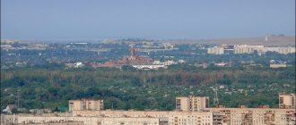
- city, administrative center of the Rybinsk district of the Krasnoyarsk Territory of the Russian Federation. Until 2008, it was an independent municipal entity, a city of regional subordination, and since 2008 it has been an urban settlement of the Rybinsk region. The population as of the end of 2011 is actually 11.4 thousand people. The city is located on the Barga River (Yenisei basin), 120 km from Krasnoyarsk.
OKATO code: 04247501 Founded: 1776 Urban-type settlement since: 1939 City since: 1948 Deviation from Moscow time, hours: 4 Geographic latitude: 55°58′ Geographical longitude: 94°42′ Height above sea level, meters: 210
Education in the city of Zaozerny
The city has two secondary schools, a gymnasium and a boarding school, and a music school.
Economy of the city of Zaozerny
bakery dairy factory furniture factory clothing factory elevator
At the time of winter 2010, all of the listed enterprises (except for furniture and clothing factories) were not functioning.
The Trans-Siberian Railway passes through the city, on which the Zaozernaya station of the Krasnoyarsk Railway is located. The city is connected by asphalt roads with the cities of Borodino, Zelenogorsk, Uyar, and the village of Rybnoye.
History of the city of Zaozerny
The first mention of a settlement of Evenki and Kyrgyz hunters near the lakes, on the site of the future city, dates back to the middle of the 17th century. In 1694, salt springs were discovered by the local population, and in the same year a salt pan was opened. The first full-fledged settlement - the settlement of Troitsko-Zaozernaya - was founded in August 1776 by economic peasants from the parish of Trinity Usolye of the Yenisei order by Roman Amosov, Semyon Dresvyansky, Ivan Pulkin. The main purpose of founding the village was the possibility of extracting mica here for the windows of churches and monasteries, Tobolsk and Moscow chambers. The settlement arose with the approval of Bishop Varlaam of Tobolsk and Siberia and was located on lands that belonged to the Trinity-Turukhansky Monastery. To develop mica, the Trinity Mica Plant was created, which gave the village its first name. In the 19th century, the village was famous for its grain trade. At the end of the 18th century, 7 versts (7.5 km) from the village on the river. The iron mine of the merchant Lobanov arose in Topolskaya, but its development was stopped in the 19th century. In the 40s of the 19th century, the settlement received the status of a village. At the beginning of the 20th century, there was a wooden church of St. John the Evangelist in the village, which was later destroyed by the Bolsheviks. In 1939 (according to other sources in 1934), the village of Troitsko-Zaozernoye was transformed into an urban-type settlement and renamed with the name “Zaozerny”, which in 1948 became a city.
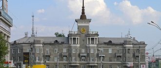
| Coat of arms of the city of Zaozerny - In an azure field, a scarlet inverted point with an inscribed silver free point; on top of everything there is a black shovel and a pickaxe crosswise, on top of which are three golden heads of ears. Approved by Decision No. 5-32R of the Zaozersk City Council of Deputies dated April 25, 2001. Author group: S. Krapotkin (Zaozerny), T. Firagina (Zaozerny), K. Mochenov, S. Isaev, R. Malanichev. | The flag of the city of Zaozerny has not yet been approved and is therefore missing |
Map
| Zaozerny: maps |
Zaozerny: photo from space (Google Maps) Zaozerny: photo from space (Microsoft Virtual Earth)
| Zaozerny. Nearest cities. Distances in km. on the map (in brackets along roads) + direction. Using the hyperlink in the distance , you can get the route (information courtesy of the AutoTransInfo website) | |||
| 1 | Borodino | 14 (16) | SE |
| 2 | Zelenogorsk | 16 (18) | NW |
| 3 | Uyar | 29 (42) | SW |
| 4 | Partisan | 56 (78) | YU |
| 5 | Irbeyskoe | 59 (81) | SE |
| 6 | Shalinskoye | 65 (132) | SW |
| 7 | Kansk | 67 (89) | IN |
| 8 | Zheleznogorsk | 78 (166) | NW |
| 9 | Podgorny | 80 () | Z |
| 10 | Aginskoe | 80 (114) | YU |
| 11 | Sosnovoborsk | 86 (146) | Z |
| 12 | Ilansky | 89 (111) | IN |
| 13 | Zykovo | 96 () | Z |
| 14 | Berezovka | 98 (127) | Z |
| 15 | Dzerzhinskoe | 101 (171) | WITH |
| 16 | Sukhobuzimskoe | 105 (224) | NW |
| 17 | Krasnoyarsk | 114 (147) | Z |
| 18 | Aban | 115 (147) | NE |
| 19 | Nizhny Ingash | 116 (139) | IN |
a brief description of
Located at the northern foot of the Eastern Sayan, on the river. Barga (tributary of the Kan River, Yenisei basin), 166 km east of Krasnoyarsk. Railway Zaozernaya station.
Territory (sq. km): 28
Information about the city of Zaozerny on the Russian Wikipedia website
Historical sketch
In August 1776 (Pospelov - 17th century), immigrants from Trinity Usolye founded the Troitsko-Zaozernaya settlement, whose residents mined mica for the windows of Tobolsk churches and monasteries, and Moscow chambers. The settlement received its name from the Trinity plant and the lakes surrounding it.
Since the 1840s, the village of Troitsko-Zaozernoye. Since 1934, the village of Zaozerny has been transformed. Renamed for anti-religious reasons.
Workers' village since 1939. City since 1948.
Economy
Factories: radio components, brick, bakery, dairy. Furniture and clothing factories. Elevator.
Near Zaozerny there is coal mining (Irsha-Borodinsky open-pit mine). Krasnoyarsk State District Power Plant-2.
In the Rybinsk region, rye, wheat, barley, oats, buckwheat, and rapeseed are grown. They raise cattle, horses, and pigs.
Deposits of mica and gold.
| Population by year (thousands of inhabitants) | |||||||
| 1939 | 9.2 | 1996 | 15.1 | 2007 | 11.3 | 2015 | 10.3 |
| 1959 | 34.7 | 1998 | 14.6 | 2008 | 11.4 | 2016 | 10.3 |
| 1967 | 31 | 2000 | 13.9 | 2010 | 11.3 | 2017 | 10.3 |
| 1970 | 27.2 | 2001 | 13.6 | 2011 | 10.7 | 2018 | 10.3 |
| 1979 | 15.8 | 2003 | 12.5 | 2012 | 10.6 | 2019 | 10.2 |
| 1989 | 15.7 | 2005 | 11.9 | 2013 | 10.4 | 2020 | 10.2 |
| 1992 | 15.6 | 2006 | 11.5 | 2014 | 10.3 | 2021 | 10.0 |
The city of Zaozerny in the Krasnoyarsk Territory
Territorial features of Zaozerny Zaozerny is the administrative center in the Rybinsk district of the Krasnoyarsk Territory. Initially it was an independent entity and had the status of a city of regional subordination. In 2008 it received the status of an urban settlement. It is located on both sides of the Barga River, which belongs to the Yenisei River basin. Zaozerny is located 120 kilometers from Krasnoyarsk. Historical information about Zaozernoye In the 17th century, the first hunting settlements were located on the territory of present-day Zaozernoye. In 1694, local residents discovered salt springs here and opened a salt pan. In 1776, a settlement with the name Troitsko-zaozernaya was founded on this site. Residents of the village were engaged in the extraction of mica, which was used for windows in churches, monasteries, and Moscow chambers. At this time, a mica mining plant was created on the territory of the settlement. In the 19th century, the Trinity-Zaozernaya settlement was also engaged in the grain trade and changed its status to a village. In 1939, the village became an urban-type settlement and already in 1948 it was given the status of a city and the name was changed to Zaozerny.
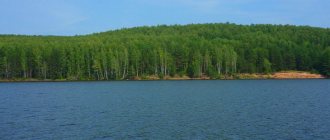
Social and economic features of the city of Zaozerny According to data for 2014, the population of the city is slightly more than 10 thousand people. The maximum number of residents in the city was noted in 1959 and amounted to more than 34.5 thousand people. Educational institutions here are represented by four schools, a boarding school and a music school. Industrial enterprises in Zaozernoye include a furniture factory, an elevator, a radio components plant, a bakery, a dairy, a brick-producing plant, and a clothing factory. Near the city, coal is mined and rye, wheat, barley, oats, buckwheat and rapeseed are grown. They are engaged in breeding cattle, pigs and horses. Near the city there are mica deposits and gold deposits. Within the city limits there is a railway station called Zaozernaya, which is part of the Trans-Siberian Railway passing through the city. Zaozerny has road connections with cities such as Zelenogorsk, Borodino, Uyar and the village of Rybnoye. Sights of Zaozerny The main attraction of Zaozerny is the Gmiryansky Bor reserve. It is a natural monument that preserves the natural state of the pine forest. The reserve was founded in 1981 and is open to everyone. Bor is a great place to relax.
Zaozerny
The city of Zaozerny is located along the banks of the Barga River, which flows into the river. Kan (tributary of the Yenisei), 160 km from Krasnoyarsk. The Trans-Siberian Railway passes through the city. On October 13, 1948, the village of Zaozerny was transformed into a city of regional subordination (population - 17,480 people). Since 1963, Zaozerny has been a city of regional subordination. It included the urban-type settlements of Irsha and Ural (since 1964) with the formation of village Soviets. In the 60s - early 80s. Zaozerny also included the town of Borodino. As of January 1, 1990, 15.7 thousand people lived in Zaozernoye. (city area is more than 0.1 thousand km), in Irsha - 2.8 thousand, in the Urals - 2.5 thousand. The city of Zaozerny was founded by economic peasants from the parish of Trinity Usolye of the Yenisei order by Roman Amosov, Semyon Dresvyansky, Ivan Pulkin in August 1776 They were assigned to the Trinity salt and iron works, located on the Usolka River in the Taseevskaya volost of the Yenisei district. The Trinity-Zaozernaya settlement arose with the approval of the Bishop of Tobolsk and Siberia Varlaam, who allowed Amosov, Dresvyansky and Pulkin to be assigned to the Rybinsk parish of the Krasnoyarsk order for the purpose of extracting mica for the windows of churches and monasteries, Tobolsk and Moscow chambers (the settlement received its name from the Trinity plant and surrounding lakes). The fact is that back in the late XVII - early XVIII centuries. fishermen on the right bank of the river. The Borg found hot salty springs. And the artisans of the Troitsk salt plant, who came here later to determine the feasibility of industrial development of salt deposits, discovered layers of mica. Mica mines arose, in which mica was broken for government premises. Bishop Varlaam wanted to have local mica to satisfy church needs. Simultaneously with the extraction of mica, Zaozernovsky miners were engaged in exploration of iron ore deposits, which the Troitsky plant needed. Soon, in exchange for debts, the mica mines and salt pans of the Troitsko-Zaozernaya settlement were transferred to the Trinity plant, and in the middle of the 19th century. - under the jurisdiction of the state treasury. At the beginning of the 19th century. A small ironworks was opened in the settlement. In 1784-1785 A wooden church with a bell tower was built in Troitsko-Zaozernaya. The formed church parish included the villages of Bargino, Vysotino, Nalobino. The settlement grew quickly. Based on the decrees of 1760-65, many participants in the peasant war under the leadership of E.I. Pugachev, Polish rebels from the army of T. Kosciuszko were exiled here. Some of these decrees actually legalized the road to Siberia for free Russian migrants from among the serfs. People from the Urals, Tambov, Tula provinces, and Ukraine were assigned to Troitsko-Zaozernaya. The first street of the settlement - Bolshoi (now Rabochaya) - was joined by two more: Tserkovnaya (Sovetskaya) and Cemetery (Kirova). Probably in the 40s. 19th century Troitsko-Zaozernaya settlement was transferred to the category of villages. In 1840, in Troitsko-Zaozerny there were 123 houses: peasant - 97, settlement - 18, anti-tract - 3, European - 3, clergy - 1, bourgeois - 1. 688 people lived (667 peasants, 13 bourgeois and 8 retired soldiers, which indicates the transition of the inhabitants of the settlement to farming). Since 1861 it has been part of the Rybinsk volost. In 1864, there were already 150 nobles and 725 (or 794?) residents in Troitsko-Zaozerny, and in 1866 - more than 1000 people. In the same year, a new church was built here (or in 1886?), and a parochial school was opened with it. In 1885, a one-class school of the Ministry of Public Education with three teachers was opened. At the end of the 19th century. Troitsko-Zaozernoye became a volost center, which included 15 settlements: Varginskaya, Vysotino, Glubokovaya, Gmiryanskaya, Ilyinka, Malaya Kamala, Mikhalevskaya, Nalobino, Novo-Georgievskaya, Orlovskaya, Uspenka, etc. The village housed a grain store, a state-owned partnership, a state-owned wine shop. In 1911, 9,754 people (1,716 households) lived in the volost, in Troitsko-Zaozerny - 1,860 people (282 households), in 1913 - 302 households. The mines and salt pans were closed. But by this time, the local residents had already developed other crafts quite well: brick making, pottery, shoe making, rope making, tar making, carpentry and turning, boat making, cooperage and wood chipping. The main occupation is agriculture. By 1917, in the villages of Gmiryansky, Mikhalevsky, Nalobino, Novo-Georgievsky there were schools of the Ministry of Public Education, in Troitsko-Zaozerny, in addition to the ministerial one, there was a parochial school. During the first Russian revolution, a committee of rallies was organized in the village of Troitsko-Zaozernoye, whose goal was to organize rallies and read reports at them. The committee was headed by the volost clerk A. Zakharov. The members were peasants I. Burachek, A. Vaulin, I. Voinov, N. Kruglov, A. Yakovlev and tradesman M. Sorokin. Political exiles also gave revolutionary speeches at rallies. On December 18, 1905, at a volost meeting in Troitsko-Zaozerny, a decision was made to abolish the local administration and refuse to pay taxes and perform duties. In December 1906, a wave of disobedience and resistance to tsarist services swept through the village. During the period of reaction, an underground Social Democratic group operated at Zaozernaya station. She conducted propaganda among the workers, issued appeals, collected funds for the party, arranged the escape of political exiles, and maintained contact with the central party bodies. The news of the October Revolution reached Troitsko-Zaozerny on November 10 - 11, 1917. Soviet power was soon established in the village. The civil war in the Troitsko-Zaozernaya volost, which was located outside the zone of active action of the North Kansk and South Kansk partisan fronts, did not acquire any widespread scope. Soviet power in the volost was restored in mid-January 1920 after the liberation of the Kansk district from the Kolchakites by units of the 30th division of the 5th Army. In 1934, the village of Troitsko-Zaozernoye was renamed into an urban-type settlement called “Zaozerny” with the formation of the Zaozernovsky Village Council. In 1935, the Zaozernovskaya MTS was formed. In 1936, there were 36 collective farms in the region. In the 70s - early 80s. The development of the economy of the city of Zaozerny was largely determined by the coal industry, represented by the Irsha-Borodinsky open-pit mine, which is currently quite developed. There are a mica factory, a sewing factory, a branch of the Krasnoyarsk furniture factory, an asphalt plant, a feed mill, a dairy plant, a branch of the Krasnoyarsk trade equipment plant (Ural village), a bakery plant, construction and road construction organizations RSU, SG1MK-641, DRSU, DPMK-1, RPO , Zaozernovskoe city inter-industry enterprise of housing and communal services, motor transport enterprise, car service station, DOSAAF, elevator, south-eastern electrical networks, energy sales.